Back Sulawèsi ACE Soelawesi Afrikaans سولاوسي Arabic سولاوسى ARZ Célebes AST Sulavesi Azerbaijani سولاوسی AZB Сулавеси Bashkir Nusa Sulawesi BAN Isla nin Sulawesi BCL
 Topographic map of Sulawesi | |
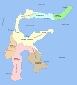
 Provincial division of Sulawesi | |
| Other names | Celebes |
|---|---|
| Geography | |
| Location | Indonesia |
| Coordinates | 02°S 121°E / 2°S 121°E |
| Archipelago | Indonesian Archipelago
Greater Sunda Islands |
| Area | 174,416.16 km2 (67,342.46 sq mi) |
| Area rank | 11th |
| Highest elevation | 3,478 m (11411 ft) |
| Highest point | Latimojong |
| Administration | |
Indonesia | |
| Provinces (capital) | |
| Largest settlement | Makassar (pop. 1,432,200) |
| Demographics | |
| Population | 20,568,411 (mid 2023 estimate) |
| Pop. density | 110.5/km2 (286.2/sq mi) |
| Ethnic groups | Makassarese, Buginese, Mandar, Minahasa, Gorontalo, Kaili, Toraja, Butonese, Muna, Tolaki, Bajau, Mongondow, Sangihe |
Sulawesi (/ˌsuːləˈweɪsi/ SOO-lə-WAY-see),[1] also known as Celebes (/ˈsɛlɪbiːz, səˈliːbiːz/ SEL-ib-eez, sə-LEE-beez),[2] is an island in Indonesia. One of the four Greater Sunda Islands, and the world's 11th-largest island, it is situated east of Borneo, west of the Maluku Islands, and south of Mindanao and the Sulu Archipelago. Within Indonesia, only Sumatra, Borneo, and Papua are larger in territory, and only Java and Sumatra are more populous.
The landmass of Sulawesi includes four peninsulas: the northern Minahasa Peninsula, the East Peninsula, the South Peninsula, and the Southeast Peninsula. Three gulfs separate these peninsulas: the Gulf of Tomini between the northern Minahasa and East peninsulas, the Tolo Gulf between the East and Southeast peninsulas, and the Bone Gulf between the South and Southeast peninsulas. The Strait of Makassar runs along the western side of the island and separates the island from Borneo.
- ^ "Sulawesi". Dictionary.com Unabridged (Online). n.d.
- ^ "Celebes". Dictionary.com Unabridged (Online). n.d.