Back السحابة الخارقة Arabic Суперклетка Bulgarian Supercèl·lula (meteorologia) Catalan ھەوری سووپەرسێڵ CKB Supercela Czech Supercelle Danish Gewitter#Superzellengewitter German Υπερκύτταρο Greek Supercelda Spanish Superzelula Basque

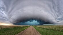
A supercell is a thunderstorm characterized by the presence of a mesocyclone, a deep, persistently rotating updraft.[1] Due to this, these storms are sometimes referred to as rotating thunderstorms.[2] Of the four classifications of thunderstorms (supercell, squall line, multi-cell, and single-cell), supercells are the overall least common and have the potential to be the most severe. Supercells are often isolated from other thunderstorms, and can dominate the local weather up to 32 kilometres (20 mi) away. They tend to last 2–4 hours.
Supercells are often put into three classification types: classic (normal precipitation level), low-precipitation (LP), and high-precipitation (HP). LP supercells are usually found in climates that are more arid, such as the high plains of the United States, and HP supercells are most often found in moist climates. Supercells can occur anywhere in the world under the right pre-existing weather conditions, but they are most common in the Great Plains of the United States in an area known as Tornado Alley. A high number of supercells are seen in many parts of Europe as well as in the Tornado Corridor (es) of Argentina, Uruguay and southern Brazil.
- ^ Glickman, Todd S., ed. (2000). Glossary of Meteorology (2nd ed.). American Meteorological Society. ISBN 978-1-878220-34-9.
- ^ "ON THE MESOCYCLONE 'DRY INTRUSION' AND TORNADOGENESIS", Archived at: Archived 2013-07-30 at the Wayback Machine, Leslie R. Lemon