Back مقاطعة سوري (فيرجينيا) Arabic Surry County, Virginia BAR সুরি কাউন্টি, ভার্জিনিয়া BPY Surry Gông (Virginia) CDO Сарри (гуо, Виргини) CE Surry County (kondado sa Tinipong Bansa, Virginia) CEB Surry County, Virginia Welsh Surry County (Virginia) German Condado de Surry (Virginia) Spanish Surry maakond Estonian
Surry County | |
|---|---|
 | |
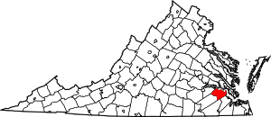
 Location within the U.S. state of Virginia | |
 Virginia's location within the U.S. | |
| Coordinates: 37°07′01″N 76°53′18″W / 37.11691°N 76.88831°W | |
| Country | |
| State | |
| Founded | 1652 |
| Named for | Surrey |
| Seat | Surry |
| Largest town | Claremont |
| Area | |
• Total | 310 sq mi (800 km2) |
| • Land | 279 sq mi (720 km2) |
| • Water | 31 sq mi (80 km2) 10.1% |
| Population (2020) | |
• Total | 6,561 |
| • Density | 21/sq mi (8.2/km2) |
| Time zone | UTC−5 (Eastern) |
| • Summer (DST) | UTC−4 (EDT) |
| Congressional district | 4th |
| Website | www |
Surry County is a county in the southeastern part of the Commonwealth of Virginia. As of the 2020 census, the population was 6,561.[1]
In 1652, Surry County was formed from the portion of James City County south of the James River. For more than 350 years it has depended on an agricultural economy.[citation needed] The county has 19 sites listed on the National Register, including a landmark occupied in 1676 known as Bacon's Castle and Chippokes Plantation (now a state park). The Jamestown Ferry provides easy access to Virginia's Historic Triangle, featuring Jamestown, Williamsburg, and Yorktown, linked by the National Park Service's Colonial Parkway.[citation needed]
The county is known for farming, curing Virginia Hams, and harvesting lumber, notably Virginia pine.
- ^ "Surry County, Virginia". United States Census Bureau. Retrieved January 30, 2022.
