Back تاغبيلاران Arabic Taqbilaran Azerbaijani Tagbilaran BCL Tagbilaran CBK-ZAM Tagbilaran CEB Tagbilaran German Tagbilaran Esperanto Tagbilaran Spanish تاگبیلاران Persian Tagbilaran French
Tagbilaran | |
|---|---|
| City of Tagbilaran | |
 Plaza Rizal | |
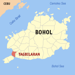
 Map of Bohol with Tagbilaran highlighted | |
Location within the Philippines | |
| Coordinates: 9°39′N 123°51′E / 9.65°N 123.85°E | |
| Country | Philippines |
| Region | Central Visayas |
| Province | Bohol |
| District | 1st district |
Incorporated
| 9 February 1742 1 July 1966 |
| Barangays | 15 (see Barangays) |
| Government | |
| • Type | Sangguniang Panlungsod |
| • mayor of Tagbilaran | Jane Cajes Yap |
| • Vice Mayor | Adam Relson L. Jala |
| • Representative | Edgardo M. Chatto |
| • City Council | Members |
| • Electorate | 70,254 voters (2022) |
| Area | |
| • Total | 36.50 km2 (14.09 sq mi) |
| Elevation | 39 m (128 ft) |
| Highest elevation | 449 m (1,473 ft) |
| Lowest elevation | 0 m (0 ft) |
| Population (2020 census)[3] | |
| • Total | 104,976 |
| • Density | 2,900/km2 (7,400/sq mi) |
| • Households | 23,078 |
| Economy | |
| • Income class | 3rd city income class |
| • Poverty incidence | 10.46 |
| • Revenue | ₱ 985.1 million (2020) |
| • Assets | ₱ 2,634 million (2020) |
| • Expenditure | ₱ 939.7 million (2020) |
| • Liabilities | ₱ 512.8 million (2020) |
| Service provider | |
| • Electricity | Bohol Light Company (BLCI) |
| Time zone | UTC+8 (PST) |
| ZIP code | 6300 |
| PSGC | |
| IDD : area code | +63 (0)38 |
| Native languages | Boholano dialect Cebuano Tagalog |
| Website | tagbilaran |
Tagbilaran, officially the City of Tagbilaran (Cebuano: Dakbayan sa Tagbilaran; Hiligaynon: Dakbanwa sang Tagbilaran; Filipino: Lungsod ng Tagbilaran), is a 3rd class component city and capital of the province of Bohol, Philippines. According to the 2020 census, it has a population of 104,976 people making it the most populous in the province.[3]
Encompassing a land area of 32.7 km2 (12.6 sq mi), with a coastline of 13 km (8.1 mi) on the southwestern part of the island, the city shares its boundaries with the towns of Cortes, Corella, and Baclayon.
Tagbilaran is the principal gateway to Bohol, 630 km (390 mi) southeast of the national capital of Manila and 72 km (45 mi) south of the regional capital, Cebu City.[5]
- ^ City of Tagbilaran | (DILG)
- ^ "2015 Census of Population, Report No. 3 – Population, Land Area, and Population Density" (PDF). Philippine Statistics Authority. Quezon City, Philippines. August 2016. ISSN 0117-1453. Archived (PDF) from the original on May 25, 2021. Retrieved July 16, 2021.
- ^ a b Census of Population (2020). "Region VII (Central Visayas)". Total Population by Province, City, Municipality and Barangay. Philippine Statistics Authority. Retrieved July 8, 2021.
- ^ "PSA Releases the 2021 City and Municipal Level Poverty Estimates". Philippine Statistics Authority. April 2, 2024. Retrieved April 28, 2024.
- ^ "Tagbiliran". Value Alliance. Retrieved January 30, 2019.


