Back إقليم تانغا Arabic TanzaniaTangaGola AVK Танга (регион) Bulgarian Regió de Tanga Catalan Tanga Region CEB ھەرێمی تانگا CKB Tanga (region) Danish Tanga (Region) German Περιφέρεια Τάνγκα Greek Regiono Tanga Esperanto
Tanga | |
|---|---|
|
From top to bottom: Building in Tanga District, Funguni Island of Pangani District and Tongoni Ruins | |
| Nickname(s): Mini Tanzania; the love region | |
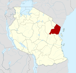
 Location in Tanzania | |
| Coordinates: 5°18′18″S 38°18′59.76″E / 5.30500°S 38.3166000°E | |
| Country | |
| Zone | Northern |
| Named for | The port of Tanga |
| Capital | Tanga |
| Districts | |
| Government | |
| • Regional Commissioner | Omary Mgumba |
| Area | |
| • Total | 26,677 km2 (10,300 sq mi) |
| • Rank | 15th of 31 |
| Highest elevation (Chambolo Peak) | 2,289 m (7,510 ft) |
| Population (2022) | |
| • Total | 2,615,597 |
| • Rank | 8th of 31 |
| • Density | 98/km2 (250/sq mi) |
| Demonym | Tangan |
| Ethnic groups | |
| • Settler | Swahili |
| • Native | Shambaa, Digo, Bondei, Segeju, Mbugu, Nguu, Dhaiso & Zigua |
| Time zone | UTC+3 (EAT) |
| Postcode | 21xxx |
| Area code | 027 |
| ISO 3166 code | TZ-25 |
| HDI (2021) | 0.569[1] medium · 8th of 25 |
| Website | Official website |
| Symbols of Tanzania | |
| Bird | Usambara Weaver |
| Butterfly |  |
| Fish | |
| Mammal |  |
| Tree | Ocotea usambarensis |
| Mineral | |
Tanga Region (Mkoa wa Tanga in Swahili) is one of Tanzania's 31 administrative regions. The region covers an area of 26,667 km2 (10,296 sq mi).[2] The region is comparable in size to the combined land area of the nation state of Burundi.[3] The regional capital is the municipality of Tanga city. Located in northeast Tanzania, the region is bordered by Kenya and Kilimanjaro Region to the north; Manyara Region to the west; and Morogoro and Pwani Regions to the south.[4] It has a coastline to the east with the Indian Ocean. According to the 2022 national census, the region had a population of 2,615,597.[5][6]
- ^ "Sub-national HDI - Area Database - Global Data Lab". hdi.globaldatalab.org. Archived from the original on 2018-09-23. Retrieved 2020-02-26.
- ^ "Tanga Region Size".
- ^ 25,680 km2 (9,920 sq mi) for Burundi at "Area size comparison". Nations Online. 2022. Retrieved 22 July 2022.
- ^ "Tanga Region Profile" (PDF). The Planning Commission, Dar es Salaam. 1997. Retrieved 22 July 2022.
- ^ "Tanzania: Regions and Cities - Population Statistics, Maps, Charts, Weather and Web Information". www.citypopulation.de. Retrieved 2024-02-09.
- ^ "Tanzania country profile" (PDF). Archived (PDF) from the original on 2021-08-31. Retrieved 2021-10-13.


