Back Thanjah ACE Tangier Afrikaans Táncher AN طنجة Arabic طانجا ARY طنجه ARZ Tánxer AST Tanjer Azerbaijani طنجه AZB Танжэр Byelorussian
Tangier
طنجة | |
|---|---|
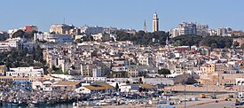
Clockwise from top: View towards the Medina, courtyard of Kasbah Palace, waterfront from Achakar, Cape Spartel lighthouse | |
| Nickname(s): The blue and white city, City of the Boughaz, Bride of the North | |
| Coordinates: 35°46′36″N 05°48′14″W / 35.77667°N 5.80389°W | |
| Country | |
| Region | Tanger-Tetouan-Al Hoceima |
| Government | |
| • Mayor | Mounir Laymouri |
| Area | |
| • Total | 124 km2 (48 sq mi) |
| Highest elevation | 230 m (750 ft) |
| Lowest elevation | 0 m (0 ft) |
| Population (2024)[2] | |
| • Total | 1,275,428 |
| • Rank | 2nd in Morocco |
| • Density | 7,026/km2 (18,200/sq mi) |
| [a] | |
| Demonym(s) | Tanjawi, Tangierian |
| Time zone | UTC+1 (CET) |
| Postal codes |
|
| Area code | 0539 |
| Website | tanger |
| |
Tangier (/tænˈdʒɪər/ tan-JEER; Arabic: طنجة, romanized: Ṭanjah, [tˤandʒa], [tˤanʒa]) or Tangiers is a city in northwestern Morocco, on the coasts of the Mediterranean Sea and the Atlantic Ocean. The city is the capital of the Tanger-Tetouan-Al Hoceima region, as well as the Tangier-Assilah Prefecture of Morocco.
Many civilisations and cultures have influenced the history of Tangier, starting from before the 10th century BCE. Starting as a strategic Phoenician town and trading centre, Tangier has been a nexus for many cultures. In 1923, it became an international zone managed by colonial powers and became a destination for many European and American diplomats, spies, bohemians, writers and businessmen. That status came to an end with Moroccan independence, in phases between 1956 and 1960.
By the early 21st century, Tangier was undergoing rapid development and modernisation. Projects include tourism projects along the bay, a modern business district called Tangier City Centre, an airport terminal, and a football stadium. Tangier's economy is set to benefit greatly from the Tanger-Med port.
- ^ "The Tangier Commune". Retrieved 2024-05-10.
- ^ "Population légale du Royaume du Maroc répartie par régions, provinces et préfectures et communes selon les résultats du Recensement général de la population et de l'habitat 2024". Site institutionnel du Haut-Commissariat au Plan du Royaume du Maroc (in French). Retrieved 2024-11-09.
- ^ "Note de présentation des premiers résultats du Recensement Général de la Population et de l'Habitat 2014" (in French). High Commission for Planning. 20 March 2015. p. 8. Retrieved 9 October 2017.


