Back تاته ياما (تشيبا) Arabic تاتیاما، چیبا AZB Татеяма (гӀала) CE Tateyama (lungsod sa Hapon) CEB Tatejama (město v Čibě) Czech Tateyama (Chiba) German Tateyama (Chiba) Spanish Tateyama Estonian Tateyama (Chiba) Basque تاتهیاما، چیبا Persian
Tateyama
館山市 | |||||||||
|---|---|---|---|---|---|---|---|---|---|

| |||||||||
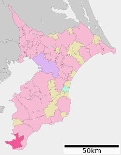
 Location of Tateyama in Chiba Prefecture | |||||||||
| Coordinates: 34°59′47.7″N 139°52′11.9″E / 34.996583°N 139.869972°E | |||||||||
| Country | Japan | ||||||||
| Region | Kantō | ||||||||
| Prefecture | Chiba | ||||||||
| Area | |||||||||
| • Total | 110.05 km2 (42.49 sq mi) | ||||||||
| Population (November 1, 2020)[2] | |||||||||
| • Total | 44,865 | ||||||||
| • Density | 410/km2 (1,100/sq mi) | ||||||||
| Time zone | UTC+9 (Japan Standard Time) | ||||||||
| Phone number | 0470-22-3111 | ||||||||
| Address | 1145-1 Hōjō, Tateyama-shi, Chiba-ken 294-8601 | ||||||||
| Climate | Cfa | ||||||||
| Website | Official website | ||||||||
| Symbols | |||||||||
| Tree | Camellia | ||||||||


Tateyama (館山市, Tateyama-shi) is a city located in Chiba Prefecture, Japan. As of 1 November 2020[update], the city had an estimated population of 44,865 in 20,558 households and a population density of 410 persons per km2.[3] The total area of the city is 110.05 square kilometres (42.49 sq mi).
- ^ "館山市基本データ" (in Japanese). Tateyama City. Retrieved 2019-10-16.
- ^ "令和元年度(平成31年度)月別人口" (in Japanese). Tateyama City. Retrieved 2019-10-16.
- ^ "Tateyama city official statistics" (in Japanese). Japan.


