Back تاونجو ARZ ဝေင်ꩻတောင်ႏအူ BLK টাউঙ্গু Bengali/Bangla Toungoo Catalan Taungoo CEB Taungu Esperanto Taungoo Spanish Taungû French Taungoo ID Toungoo Italian
Taungoo
တောင်ငူမြို့ | |
|---|---|
Town | |
 | |
| Coordinates: 18°56′N 96°26′E / 18.933°N 96.433°E | |
| Country | |
| Division | |
| District | Taungoo District |
| Founded | 17 April 1279 |
| Government | |
| • Type | District government and Township government |
| Population (2014)[1] | |
| • Urban | 108,569 |
| • Ethnicities | Burman Karen |
| • Religions | Theravada Buddhism Christianity |
| Time zone | UTC+6:30 (MST) |

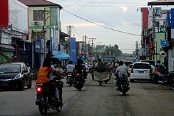
Taungoo (Burmese: တောင်ငူမြို့; MLCTS: taung ngu mrui., pronounced [tàʊɰ̃ŋù mjo̰] Tauñngu myoú; S'gaw Karen: တီအူ), also spelled Toungoo and formerly Toung-ngú,[2] is a district-level city in the Bago Region of Myanmar, 220 km from Yangon, towards the north-eastern end of the division, with mountain ranges to the east and west. The main industry is in forestry products, with teak and other hardwoods extracted from the mountains. The city is known for its areca palms and betel nut chewing.
The city is famous in Burmese history for the Toungoo dynasty which ruled the country for over 200 years between the 16th and 18th centuries. Taungoo was the capital of Burma in 1510–1539 and 1551–1552.
Kaytumadi new city (new city of Taungoo) is the central command of the southern command division region of Armed Forces (Tatmadaw). Hanthawaddy United Football Club is based in Taungoo.
- ^ Cite error: The named reference
citypopulationwas invoked but never defined (see the help page). - ^ "Toung-ngú", Encyclopaedia Britannica, vol. XXIII (9th ed.), 1882.
