Back Releu (cheografía) AN تضاريس Arabic Relieve terrestre AST Relyef Azerbaijani Рэльеф (геаграфія) Byelorussian Рэльеф BE-X-OLD Релеф (геоморфология) Bulgarian Torosennadur Breton Reljef (geografija) BS Relleu (geografia) Catalan
This article needs additional citations for verification. (July 2012) |


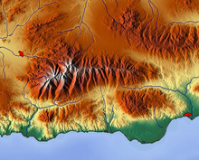
Terrain (from Latin: terra 'earth'), alternatively relief or topographical relief, is the dimension and shape of a given surface of land. In physical geography, terrain is the lay of the land. This is usually expressed in terms of the elevation, slope, and orientation of terrain features. Terrain affects surface water flow and distribution. Over a large area, it can affect weather and climate patterns. Bathymetry is the study of underwater relief, while hypsometry studies terrain relative to sea level.