Back Texas Triangle AST تکزاس تریانقل AZB Texanisches Dreieck German مثلث تگزاس Persian Triangle texan French Texas Triangle Italian テキサス・トライアングル Japanese 德克薩斯州三角地帶 Chinese
Texas Triangle Megaregion | |
|---|---|
From top to bottom: Houston, Austin, Fort Worth, San Antonio, Dallas | |
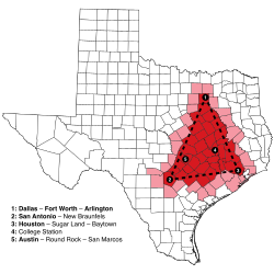
 The cities and counties in or near the Texas Triangle, a megaregion of the U.S. state of Texas: City names in bold in the map legend are in the top 10 most populous Texas cities. | |
| Country | |
| State | |
| Area | |
| • Metro | 160,000 km2 (60,000 sq mi) |
| Population | |
| • Estimate (2020) | 20,852,272[1] |
| • Metro density | 130/km2 (348/sq mi) |
| GDP | |
| • Total | $1.3 trillion (2018) |
The Texas Triangle is a region of Texas that contains the state's five largest cities and is home to the majority of the state's population. The Texas Triangle is formed by the state's four main urban centers, Austin, Dallas-Fort Worth, Houston, and San Antonio, connected by Interstate 45, Interstate 10, and Interstate 35. In 2020, the population of the Texas Triangle reached nearly 21 million following rapid growth across much of Texas.[1] The Texas Triangle is one of eleven megaregions in the United States, clusters of urban areas that share economic and cultural ties.
In 2004, the Texas Triangle contained five of the 20 largest cities in the U.S. and was home to more than 70% of all Texans, with a population of 13.8 million.[3] In the next 40 years, the population of the Texas Triangle is projected to increase by more than 65%,[4] or 10 million people, and comprise 78% of all Texans.
Additional metropolitan areas in the region include Bryan–College Station, Killeen–Temple–Fort Hood, and Waco. Twelve micropolitan statistical areas are within the Triangle, which includes 66 counties.[5] Beaumont, located east of Houston, has been considered part of the Texas Triangle by numerous studies dating from 2000.[6][7][8][9][10] Burleson County is the center of the Texas Triangle.
- ^ a b "The Texas Triangle Megaregion Nears 21 Million Residents | TNE". texasnewsexpress.com. Retrieved October 18, 2020.
- ^ "Triumph of the Triangle: How Texas can hold onto its urban economic powerhouse", kinder.rice.edu
- ^ "The Simple Economics of the Texas Triangle - Houston Business, Jan. 2004 - FRB Dallas". Archived from the original on February 2, 2004. Retrieved July 12, 2014.
- ^ "Reinventing The Texas Triangle - UTexas CSD - 2009" (PDF). utexas.edu. Retrieved March 25, 2014.
- ^ "Triangle Census – Megas, Metros & Micros". Archived from the original on July 6, 2011. Retrieved December 8, 2009.
- ^ "MegaRegions +MetroProsperity". Houston Tomorrow and America 2050. August 4, 2009. Retrieved November 8, 2014.
- ^ Kent Butler, Sara Hammerschmidt, Frederick Steiner and Ming Zhang. "REINVENTING THE TEXAS TRIANGLE Solutions for Growing Challenges" (PDF). The University of Texas at Austin School of Architecture Center for Sustainable Development. pp. 6, 10. Archived from the original (PDF) on September 30, 2011. Retrieved November 8, 2014.
{{cite web}}: CS1 maint: multiple names: authors list (link) - ^ Dan Seedah and Robert Harrison (September 2011). "Megaregion Freight Movements: A Case Study of the Texas Triangle" (PDF). Center for Transportation Research University of Texas at Austin (Form DOT F 1700.7 (8-72)). pp. 37–38. Retrieved November 8, 2014.
- ^ Michael Neuman and Elise Bright (May 2008). "TEXAS URBAN TRIANGLE Framework for future growth" (PDF). Texas Transportation Institute Texas A&M University System College Station, Texas 77843-3135. pp. 4–6. Retrieved November 8, 2014.
- ^ Ming Zhang, Frederick Steiner, Kent Butler (April 4, 2007). "Connecting the Texas Triangle: Economic Integration and Transportation Coordination" (PDF). The Healdsburg Research Seminar on MegaRegions. p. 31. Retrieved March 11, 2018.
{{cite web}}: CS1 maint: multiple names: authors list (link)


