Back نهر ثاميس ARZ Thames River (suba sa Kanada) CEB Thames River (Ontario) German Rivière Thames (Ontario) French Թեմս (գետ, թափվում է Սենտ Քլեր) Armenian Thames (rzeka w Ontario) Polish Темс (река, впадает в Сент-Клэр) Russian Thames River (Ontario) Swedish
| Thames River Antler River | |
|---|---|
 North Thames River just upstream from its confluence with the Avon River near Stratford, Ontario | |
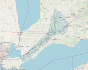
 Watershed of Thames River in Ontario | |
| Etymology | after the River Thames in England |
| Native name | Deshkaan-ziibi / Eshkani-ziibi (Ojibwe) |
| Location | |
| Country | Canada |
| Province | Ontario |
| Region | Southwestern Ontario |
| Physical characteristics | |
| Source | |
| • location | Near Tavistock |
| Mouth | Lake Saint Clair |
• location | Lighthouse Cove |
• coordinates | 42°19′9″N 82°27′15″W / 42.31917°N 82.45417°W[1] |
• elevation | 173 m (568 ft)[2] |
| Length | 273 km (170 mi)[3] |
| Basin size | 5,825 km2 (2,249 sq mi)[3] |
| Discharge | |
| • location | Chatham[4] |
| • average | 52.9 m3/s (1,870 cu ft/s)[4] |
| • minimum | 8.25 m3/s (291 cu ft/s) |
| • maximum | 1,090 m3/s (38,000 cu ft/s) |
| Basin features | |
| River system | Great Lakes Basin |
The Thames River /tɛmz/[5] is located in southwestern Ontario, Canada.
The Thames flows southwest for 273 kilometres (170 mi)[3] through southwestern Ontario, from the Town of Tavistock through the cities of Woodstock, London and Chatham to Lighthouse Cove on Lake St. Clair. Its drainage basin is 5,825 square kilometres (2,249 sq mi).[3]
The river is also known as Deshkaan-ziibi / Eshkani-ziibi ("Antler River") in the Ojibwe language, spoken by Anishnaabe peoples who, along with the Neutrals prior to their disappearance in the 17th century, have lived in the area since before Europeans arrived. This name was anglicized as "Escunnisepe" as the first English name of the river. In 1793, Lieutenant Governor John Graves Simcoe named the river after the River Thames in England.[6] Early French Canadians referred to it as La Tranche, for the wide and muddy waters of its lower section.
Much of the Thames was formerly surrounded by deciduous Carolinian forests, but much of this forest has been cleared to permit agriculture and other forms of development.
Two conservation authorities together have jurisdiction over the Thames River watershed, the Upper Thames River Conservation Authority and Lower Thames Valley Conservation Authority, and work to prevent damaging floods and undertake other resource management activities.
- ^ "Thames River". Geographical Names Data Base. Natural Resources Canada.
- ^ Google Earth elevation for GNIS coordinates
- ^ a b c d "Thames River Fact Sheet". Canadian Heritage Rivers System. Archived from the original on 28 March 2010. Retrieved 13 October 2010.
- ^ a b Station 02GE003 (Thames River at Thamesville), Archived Hydrometric Data Archived 2012-12-16 at archive.today, Water Survey of Canada.
- ^ Geographical Dictionary of the World. Concept Publishing Company. ISBN 9788172680121 – via Google Books.
- ^ Worsfold, Elliot (July 18, 2017). "The politics of reclaiming, not renaming". The Nova Scotia Advocate. Retrieved 10 March 2019.