Back ثاندر باى (مقاطعه) ARZ Thunder Bay District BAR Thunder Bay District CEB Thunder Bay District German Distrito de Thunder Bay Spanish بخش ثاندر بی Persian District de Thunder Bay French Distretto di Thunder Bay Italian サンダーベイ地区 Japanese Dystrykt Thunder Bay Polish
Thunder Bay District | |
|---|---|
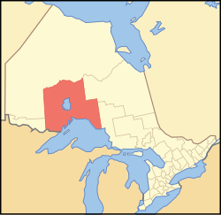
 Location of Thunder Bay District in Ontario | |
| Coordinates: 50°N 088°W / 50°N 88°W | |
| Country | Canada |
| Province | Ontario |
| Region | Northwestern Ontario |
| Created | 1871 |
| Government | |
| • MPs | Carol Hughes (NDP) Patty Hajdu (Liberal) Marcus Powlowski (Liberal)[1] |
| • MPPs | Michael Gravelle (OLP) Michael Mantha (NDP) Judith Monteith-Farrell (NDP) |
| Area | |
| • Land | 103,719.51 km2 (40,046.33 sq mi) |
| Elevation | 220 m (720 ft) |
| Highest elevation | 640 m (2,100 ft) |
| Lowest elevation | 183 m (600 ft) |
| Population (2016)[4] | |
| • Total | 146,048 |
| • Density | 1.4/km2 (4/sq mi) |
| Time zones | |
| East of 90° west | UTC-05:00 (Eastern) |
| • Summer (DST) | UTC-04:00 (EDT) |
| West of 90° west | UTC-06:00 (Central) |
| • Summer (DST) | UTC-05:00 (CDT) |
| Postal code span | |
| Area code | 807 |
| Largest communities [5] | Thunder Bay (109,140) Oliver Paipoonge (5,757) Greenstone (4,906) |

Thunder Bay District is a district and census division in Northwestern Ontario in the Canadian province of Ontario. The district seat is Thunder Bay.
In 2016, the population was 146,048. The land area is 103,719.51 square kilometres (40,046.33 sq mi); the population density was 1.4 per square kilometre (3.6/sq mi).[2] Most of the district (93.5%) is unincorporated and part of the Unorganized Thunder Bay District.
- ^ https://www.ourcommons.ca/members/en/marcus-powlowski(105437)
- ^ a b Cite error: The named reference
cp2011was invoked but never defined (see the help page). - ^ Highest point is 640m, located in Pukaskwa National Park. Thunder Bay is at 183m. 220 is an estimate
- ^ Cite error: The named reference
cp2016was invoked but never defined (see the help page). - ^ Compilation of Northwestern Ontario's 2006 census data