Back Tigris Afrikaans Tigris ALS ጤግሮስ Amharic دجلة Arabic ܕܩܠܬ ARC نهر دجله ARZ Tigris AST Dəclə Azerbaijani دجله چایی AZB Тигр Bashkir
| Tigris | |
|---|---|
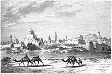
 Tigris river in Baghdad | |
 Map of the Tigris–Euphrates river system | |
| Location | |
| Country | Turkey, Syria, Iraq |
| Source region | Armenian Highlands[1] |
| Cities | Elazığ, Diyarbakır, Mosul, Baghdad |
| Physical characteristics | |
| Source | Lake Hazar[2] |
| • location | Gölardı, Turkey |
| • coordinates | 38°29′0″N 39°25′0″E / 38.48333°N 39.41667°E |
| • elevation | 1,150 m (3,770 ft) |
| Mouth | Shatt al-Arab |
• location | Al-Qurnah, Iraq |
• coordinates | 31°0′18″N 47°26′31″E / 31.00500°N 47.44194°E |
• elevation | 1 m (3.3 ft) |
| Length | 1,900 km (1,200 mi) |
| Basin size | 375,000 km2 (145,000 sq mi) |
| Discharge | |
| • location | Baghdad |
| • average | 1,014 m3/s (35,800 cu ft/s) |
| • minimum | 337 m3/s (11,900 cu ft/s) |
| • maximum | 2,779 m3/s (98,100 cu ft/s) |
| Basin features | |
| Progression | Shatt al-Arab → Persian Gulf |
| River system | Tigris–Euphrates river system |
| Tributaries | |
| • left | Garzan, Botan, Khabur, Greater Zab, Lesser Zab, 'Adhaim, Cizre, Diyala |
| • right | Wadi Tharthar |
[3][4] | |

The Tigris (/ˈtaɪɡrɪs/ TY-griss; see below) is the eastern of the two great rivers that define Mesopotamia, the other being the Euphrates. The river flows south from the mountains of the Armenian Highlands through the Syrian and Arabian Deserts, before merging with the Euphrates and reaching to the Persian Gulf.
The Tigris passes through historical cities like Mosul, Tikrit, Samarra, and Baghdad. It is also home to archaeological sites and ancient religious communities, including the Mandaeans, who use it for baptism. In ancient times, the Tigris nurtured the Assyrian Empire, with remnants like the relief of King Tiglath-Pileser.
Today, the Tigris faces modern threats from geopolitical instability, dam projects, poor water management, and climate change, leading to concerns about its sustainability. Efforts to protect and preserve the river's legacy are ongoing, with local archaeologists and activists working to safeguard its future.
- ^ Stone, Michael E.; Topchyan, Aram (2022). Jews in Ancient and Medieval Armenia: First Century BCE to Fourteenth Century CE. Oxford University Press. p. 17. ISBN 978-0-19-758207-7.
- ^ Nicoll, Kathleen. "Geomorphic Evolution of the Upper Basin of the Tigris River, Turkey". University of Utah. Archived from the original on 2023-10-25. Retrieved 2021-09-05.
- ^ Isaev, V.A.; Mikhailova, M.V. (2009). "The hydrology, evolution, and hydrological regime of the mouth area of the Shatt al-Arab River". Water Resources. 36 (4): 380–395. doi:10.1134/S0097807809040022. S2CID 129706440.
- ^ Kolars, J.F.; Mitchell, W.A. (1991). The Euphrates River and the Southeast Anatolia Development Project. Carbondale: Southern Illinois University Press. pp. 6–8. ISBN 0-8093-1572-6.