Back جزر تيوي Arabic Illes Tiwi Catalan Tiwi Islands (kapuloan) CEB Tiwi Islands German Islas Tiví Spanish جزایر تیوا Persian Îles Tiwi French Illas Tiwi Galician टिवी द्वीप समूह Hindi Kepulauan Tiwi ID
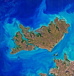
 Satellite image of the Tiwi Islands, Melville (top right) and Bathurst (left) with the Australian mainland (bottom right) | |
| Geography | |
|---|---|
| Location | Timor Sea |
| Coordinates | 11°36′S 130°49′E / 11.600°S 130.817°E |
| Total islands | 11 |
| Major islands | Melville Island Bathurst Island |
| Area | 8,320 km2 (3,210 sq mi) |
| Coastline | 1,016 km (631.3 mi) |
| Administration | |
Australia | |
| State or territory | Northern Territory |
| LGA | Tiwi Islands Region |
| Demographics | |
| Population | 2,348[1] (2021 census) |
| Languages | Tiwi |
| Ethnic groups | Tiwi |
| Additional information | |
| Official website | www |
 Flag of the Tiwi Islands (Tiwi: pantirra Ratuati Irara). | |
The Tiwi Islands (Tiwi: Ratuati Irara meaning "two islands") are part of the Northern Territory, Australia, 80 km (50 mi) to the north of Darwin adjoining the Timor Sea. They comprise Melville Island, Bathurst Island, and nine smaller uninhabited islands, with a combined area of 8,320 square kilometres (3,212 sq mi).
Inhabited before European settlement by the Tiwi, an Aboriginal Australian people, the islands' population was 2,348 at the 2021 census.[1]
The Tiwi Land Council is one of four land councils in the Northern Territory. It is a representative body with statutory authority under the Aboriginal Land Rights (Northern Territory) Act 1976, and has responsibilities under the Native Title Act 1993 and the Pastoral Land Act 1992.
- ^ a b Australian Bureau of Statistics (28 June 2022). "Tiwi Islands". 2021 Census QuickStats. Retrieved 21 September 2022.

