Back توني (نهر) Arabic نهر تونى ARZ Тонэ Byelorussian Тоне (река) Bulgarian Riu Tone Catalan Tone Czech Tone (Fluss) German Tone (rivero) Esperanto Río Tone Spanish Tone ibaia Basque
You can help expand this article with text translated from the corresponding article in Japanese. (October 2018) Click [show] for important translation instructions.
|
| Tone River | |
|---|---|
 | |
 | |
| Native name | 利根川 (Japanese) |
| Location | |
| Country | Japan |
| Physical characteristics | |
| Source | Mount Ōminakami |
| • location | Minakami, Gunma |
| • coordinates | 37°03′16″N 139°06′05″E / 37.05444°N 139.10139°E |
| • elevation | 1,831 m (6,007 ft) |
| Mouth | Pacific Ocean |
• location | Chōshi, Chiba |
• coordinates | 35°44′45″N 140°51′07″E / 35.74583°N 140.85194°E |
• elevation | 0 m (0 ft) |
| Length | 322 km (200 mi) |
| Basin size | 16,840 km2 (6,500 sq mi) |
| Discharge | |
| • average | 256 m3/s (9,000 cu ft/s) |
 | |
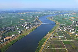
The Tone River (利根川, Tone-gawa) is a river in the Kantō region of Japan. It is 322 kilometers (200 mi) in length (the second longest in Japan after the Shinano) and has a drainage area of 16,840 square kilometers (6,500 sq mi) (the largest in Japan). It is nicknamed Bandō Tarō (坂東太郎); Bandō is an obsolete alias of the Kantō Region, and Tarō is a popular given name for an oldest son.[1] It is regarded as one of the "Three Greatest Rivers" of Japan, the others being the Yoshino in Shikoku and the Chikugo in Kyūshū.