Back Торвайн Bulgarian Torfaen Breton Torfaen Catalan Torfaen County Borough CEB Torfaen Welsh Torfaen German Torfaen Esperanto Torfaen Spanish Torfaen Estonian Torfaen Basque
Torfaen County Borough
Bwrdeistref Sirol Torfaen (Welsh) | |
|---|---|
| |
| Motto: United We Serve | |
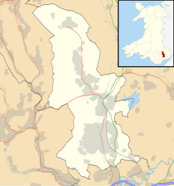
Torfaen shown within Wales | |
| Coordinates: 51°43′N 3°03′W / 51.717°N 3.050°W | |
| Sovereign state | United Kingdom |
| Country | Wales |
| Preserved county | Gwent |
| Incorporated | 1 April 1974 |
| Unitary authority | 1 April 1996 |
| Administrative HQ | Pontypool |
| Government | |
| • Type | Principal council |
| • Body | Torfaen County Borough Council |
| • Control | Labour |
| • MPs | Nick Thomas-Symonds (L) |
| • MSs | |
| Area | |
| • Total | 49 sq mi (126 km2) |
| • Rank | 20th |
| Population (2022)[2] | |
| • Total | 92,860 |
| • Rank | 18th |
| • Density | 1,910/sq mi (739/km2) |
| Welsh language (2021) | |
| • Speakers | 8.2% |
| • Rank | 19th |
| Time zone | UTC+0 (GMT) |
| • Summer (DST) | UTC+1 (BST) |
| ISO 3166 code | GB-TOF |
| GSS code | W06000020 |
| Website | www |
Torfaen (/tɔːrˈvaɪn/; [tɔrˈvaɪn]) is a county borough in the south-east of Wales. Torfaen is bordered by the county of Monmouthshire to the east, the city of Newport to the south, and the county boroughs of Caerphilly and Blaenau Gwent to the south-west and north-west. It is within the boundaries of the historic county of Monmouthshire, and between 1974 and 1996 was a district of Gwent, until it was reconstituted as a principal area in 1996.
- ^ "About the Council". Torfaen County Borough Council. Retrieved 6 August 2024.
- ^ a b "Mid-Year Population Estimates, UK, June 2022". Office for National Statistics. 26 March 2024. Retrieved 3 May 2024.
- ^ "How life has changed in Torfaen: Census 2021". Office for National Statistics. 19 January 2023. Retrieved 6 August 2024.


