Back Straat van Torres-eilande Afrikaans جزر مضيق توريس Arabic Illes de l'estret de Torres Catalan Torres Strait Islands CEB Ostrovy Torresova průlivu Czech Ynysoedd Culfor Torres Welsh Torres-Strait-Inseln German Insuloj de la Toresa Markolo Esperanto Islas del estrecho de Torres Spanish Torres itsasarteko uharteak Basque
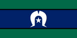
 Flag of the Torres Strait Islanders | |
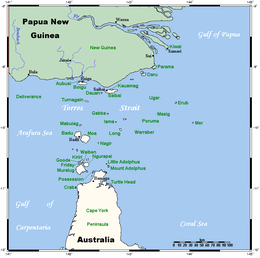
 Location of the Torres Strait Islands, between Cape York Peninsula, Queensland, Australia and Papua New Guinea. | |
| Geography | |
|---|---|
| Coordinates | 10°34′44″S 142°13′12″E / 10.579°S 142.220°E |
| Area | 566 km2 (219 sq mi) |
| Administration | |
Australia | |
| Torres Strait Regional Authority | |
| Capital and largest city | Thursday Island |
| Chairmana Chief Executive Officera | Napau Pedro Stephen Leilani Bin-Juda |
| Demographics | |
| Demonym | Torres Strait Islander |
| Population | 4,514[1] (2016) |
| Languages | English; important local languages: Kalau Lagau Ya, Meriam Mir, Torres Strait Creole |
The Torres Strait Islands are an archipelago of at least 274 small islands in the Torres Strait, a waterway separating far northern continental Australia's Cape York Peninsula and the island of New Guinea. They span an area of 48,000 km2 (19,000 sq mi), but their total land area is 566 km2 (219 sq mi).
The Islands are inhabited by the indigenous Torres Strait Islanders. Lieutenant James Cook first claimed British sovereignty over the eastern part of Australia at Possession Island in 1770, but British administrative control only began in the Torres Strait Islands in 1862. The islands are now mostly part of Queensland, a constituent State of the Commonwealth of Australia, but are administered by the Torres Strait Regional Authority, a statutory authority of the Australian federal government. A few islands very close to the coast of mainland New Guinea belong to the Western Province of Papua New Guinea, most importantly Daru Island with the provincial capital, Daru.
Only 17 of the islands are inhabited.[2] The Torres Strait Islands' population was recorded at 4,514 in the 2016 Australian census, with 91.8% of these identifying as Indigenous Torres Strait Island peoples. Although counted as Indigenous Australians, Torres Strait Islander peoples, being predominantly Melanesian, are ethnically and culturally different from Aboriginal Australians.
- ^ Cite error: The named reference
Census2016Ywas invoked but never defined (see the help page). - ^ Hall, Nina L.; Barnes, Samuel; Canuto, Condy; Nona, Francis; Redmond, Andrew M. (April 2021). "Climate change and infectious diseases in Australia's Torres Strait Islands". Australian and New Zealand Journal of Public Health. 45 (2): 122–128. doi:10.1111/1753-6405.13073. Retrieved 6 October 2023.