| Part of a series on |
| Tropical cyclones |
|---|
 |
|
Outline Media coverage |
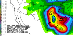
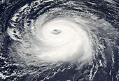
Tropical cyclone rainfall forecasting involves using scientific models and other tools to predict the precipitation expected in tropical cyclones such as hurricanes and typhoons. Knowledge of tropical cyclone rainfall climatology is helpful in the determination of a tropical cyclone rainfall forecast. More rainfall falls in advance of the center of the cyclone than in its wake. The heaviest rainfall falls within its central dense overcast and eyewall. Slow moving tropical cyclones, like Hurricane Danny and Hurricane Wilma, can lead to the highest rainfall amounts due to prolonged heavy rains over a specific location. However, vertical wind shear leads to decreased rainfall amounts, as rainfall is favored downshear and slightly left of the center and the upshear side is left devoid of rainfall. The presence of hills or mountains near the coast, as is the case across much of Mexico, Haiti, the Dominican Republic, much of Central America, Madagascar, Réunion, China, and Japan act to magnify amounts on their windward side due to forced ascent causing heavy rainfall in the mountains. A strong system moving through the mid latitudes, such as a cold front, can lead to high amounts from tropical systems, occurring well in advance of its center. Movement of a tropical cyclone over cool water will also limit its rainfall potential. A combination of factors can lead to exceptionally high rainfall amounts, as was seen during Hurricane Mitch in Central America.[1]
Use of forecast models can help determine the magnitude and pattern of the rainfall expected. Climatology and persistence models, such as r-CLIPER, can create a baseline for tropical cyclone rainfall forecast skill. Simplified forecast models, such as the Kraft technique and the eight and sixteen-inch rules, can create quick and simple rainfall forecasts, but come with a variety of assumptions which may not be true, such as assuming average forward motion, average storm size, and a knowledge of the rainfall observing network the tropical cyclone is moving towards. The forecast method of TRaP assumes that the rainfall structure the tropical cyclone currently has changes little over the next 24 hours. The global forecast model which shows the most skill in forecasting tropical cyclone-related rainfall in the United States is the ECMWF IFS (Integrated Forecasting System).[2][3]
- ^ Federal Emergency Management Agency. Are You Ready? Archived 2006-06-29 at the Wayback Machine Retrieved on 2006-04-05.
- ^ "Tropical Cyclone Guidance". Archived from the original on 2017-09-10. Retrieved 2017-09-10.
- ^ "US forecast models have been pretty terrible during Hurricane Irma". 8 September 2017. Archived from the original on 10 September 2017. Retrieved 10 September 2017.
