Back مقاطعة تسوين وان Arabic Tsuen Wan District CEB Tsuen Wan District German Distrito de Tsuen Wan Spanish Tsuen Wan barrutia Basque منطقه تسوئن وان Persian Tsuen Wan (piiri) Finnish Tsuen Wan (district) French Tshiên-vân-khî HAK צואן ואן HE
This article needs additional citations for verification. (September 2016) |
Tsuen Wan
荃灣區 | |
|---|---|
| Tsuen Wan District | |
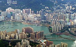
 Day view of Tsuen Wan District | |
 | |
 Location of Tsuen Wan District within Hong Kong | |
| Coordinates: 22°21′46″N 114°07′45″E / 22.36281°N 114.12907°E | |
| Statutorily-defined area | New Territories |
| Region | Hong Kong (special administrative region) |
| Country | China |
| Constituencies | 17[needs update] |
| Government | |
| • District Council Chairman | Sumly Chan Yuen Sum[needs update] |
| • District Council Vice-Chairman | Yau Kam Ping |
| Area | |
| • Total | 60.70 km2 (23.44 sq mi) |
| Population (2016[1]) | |
| • Total | 318,916 |
| • Density | 5,300/km2 (14,000/sq mi) |
| Time zone | UTC+8 (Hong Kong Time) |
| Location of district office and district council | 174-208 Castle Peak Road – Tsuen Wan[[]], Tsuen Wan |
| Website | Tsuen Wan District Council |
| Tsuen Wan District | |||||||||||||||||||
|---|---|---|---|---|---|---|---|---|---|---|---|---|---|---|---|---|---|---|---|
| Traditional Chinese | 荃灣區 | ||||||||||||||||||
| Simplified Chinese | 荃湾区 | ||||||||||||||||||
| Cantonese Yale | Tsyùhn Wāan Kēui | ||||||||||||||||||
| Jyutping | Cyun4 waan1 keoi1 | ||||||||||||||||||
| |||||||||||||||||||

Tsuen Wan District is one of the 18 districts of Hong Kong. It is located in the New Territories and is served by the Tsuen Wan line of the MTR metro system. Its area is 60.7 km2.[2] Its residents, who mostly live in Tsuen Wan Town, enjoy the highest income in the New Territories.[citation needed]
Part of the Tsuen Wan New Town is located in the Tsuen Wan District. An exclave of the district is located on the island of Ma Wan and the northeastern part of Lantau island (including Tsing Chau Tsai Peninsula and Yam O).
The Hong Kong Disneyland Resort is within the boundary of Tsuen Wan District (and partially in the neighbouring Islands District).[3][4][5]
- ^ "2016 Population By-Census: Summary Result Table 201a Population by District". Census and Statistics Department, Hong Kong Government. 2017. Retrieved 23 May 2018.
- ^ "Hong Kong: Population, Area & Density by District Board District: 1999". Demographia. 2000. Retrieved 30 August 2008.
- ^ "1999 District council electoral boundaries index map" (PDF). www.eac.hk.
- ^ "EAC - Electoral Boundary Maps".
- ^ "2019 District Council Election - Constituency Boundary Maps".