Back تكوين تو ميدسن Arabic Formació de Two Medicine Catalan Souvrství Two Medicine Czech Formación Two Medicine Spanish Formation de Two Medicine French Formasi Two Medicine ID ツーメディスン累層 Japanese Two Medicine Formation Dutch Formação Two Medicine Portuguese
| Two Medicine Formation | |
|---|---|
| Stratigraphic range: Campanian ~ | |
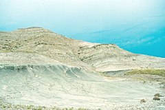
 Outcrop of the Two Medicine Formation near "Egg Mountain" in northern Montana | |
| Type | Geological formation |
| Sub-units | Rock City Member, Shields Crossing Member, Hagans Crossing Member, Flag Butte Member |
| Underlies | Bearpaw Shale |
| Overlies | Virgelle Sandstone |
| Thickness | 600 m (2,000 ft) (western portion) |
| Lithology | |
| Primary | Sandstone |
| Location | |
| Coordinates | 48°04′27″N 112°17′58″W / 48.07417°N 112.29944°W |
| Approximate paleocoordinates | 55°18′N 77°48′W / 55.3°N 77.8°W |
| Region | |
| Country | |
| Type section | |
| Named for | Two Medicine River |
| Named by | Stebinger |
| Year defined | 1914 |
The Two Medicine Formation is a geological formation, or rock body, in northwestern Montana and southern Alberta that was deposited between 82.4 Ma and 74.4 Ma, during Campanian (Late Cretaceous) time. It crops out to the east of the Rocky Mountain Overthrust Belt, and the western portion (about 600 metres or 2,000 feet thick) of this formation is folded and faulted while the eastern part, which thins out into the Sweetgrass Arch, is mostly undeformed plains. Below the formation are the nearshore (beach and tidal zone) deposits of the Virgelle Sandstone, and above it is the marine Bearpaw Shale. Throughout the Campanian, the Two Medicine Formation was deposited between the western shoreline of the Late Cretaceous Interior Seaway and the eastward advancing margin of the Cordilleran Overthrust Belt. The Two Medicine Formation is mostly sandstone, deposited by rivers and deltas.

