Back نظام الطرق السريعة المرقمة بالولايات المتحدة Arabic Магистрална система на Съединените щати Bulgarian U.S. Highway System Danish United States Numbered Highway System German Red de carreteras federales de Estados Unidos Spanish سیستم عددی بزرگراه در ایالت متحده آمریکا Persian U.S. Route French Az USA szövetségi országúthálózata Hungarian U.S. Routes Italian アメリカ国道 Japanese
| United States Numbered Highway System | |
|---|---|
 | |
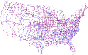
 Map of the present U.S. Highway network; Purple are double-digit U.S. Routes, blue are triple-digit U.S. Routes, and orange are Interstate Routes | |
| System information | |
| Maintained by primarily state or local governments; numbers and routings approved by AASHTO[a] | |
| Length | 157,724 mi[b] (253,832 km) |
| Formed | November 11, 1926[1] |
| Highway names | |
| US Highways | U.S. Highway nn (US nn) U.S. Route nn (US nn) |
| System links | |
The United States Numbered Highway System (often called U.S. Routes or U.S. Highways) is an integrated network of roads and highways numbered within a nationwide grid in the contiguous United States. As the designation and numbering of these highways were coordinated among the states, they are sometimes called Federal Highways, but the roadways were built and have always been maintained by state or local governments since their initial designation in 1926.
The route numbers and locations are coordinated by the American Association of State Highway and Transportation Officials (AASHTO).[4] The only federal involvement in AASHTO is a nonvoting seat for the United States Department of Transportation. Generally, most north-to-south highways are odd-numbered, with the lowest numbers in the east and the highest in the west, while east-to-west highways are typically even-numbered, with the lowest numbers in the north, and the highest in the south, though the grid guidelines are not rigidly followed, and many exceptions exist. Major north–south routes generally have numbers ending in "1", while major east–west routes usually have numbers ending in "0".[1][c] Three-digit numbered highways are generally spur routes of parent highways; for example, U.S. Route 264 (US 264) is a spur off US 64. Some divided routes, such as US 19E and US 19W, exist to provide two alignments for one route. Special routes, which can be labeled as alternate, bypass or business, depending on the intended use, provide a parallel routing to the mainline U.S. Highway.
Before the U.S. Routes were designated, auto trails designated by auto trail associations were the main means of marking roads through the United States. These were private organizations, and the system of road marking at the time was haphazard and not uniform. In 1925, the Joint Board on Interstate Highways, recommended by the American Association of State Highway Officials (AASHO), worked to form a national numbering system to rationalize the roads. After several meetings, a final report was approved by the U.S. Department of Agriculture in November 1925. After getting feedback from the states, they made several modifications; the U.S. Highway System was approved on November 11, 1926.
Expansion of the U.S. Highway System continued until 1956, when the Interstate Highway System was laid out and began construction under the administration of President Dwight D. Eisenhower. After the national implementation of the Interstate Highway System, many U.S. Routes that had been bypassed or overlaid with Interstate Highways were decommissioned and removed from the system. In some places, the U.S. Routes remain alongside the Interstates and serve as a means for interstate travelers to access local services and as secondary feeder roads or as important major arteries in their own right. In other places, where there are no nearby Interstate Highways, the U.S. Routes often remain as the most well-developed roads for long-distance travel. While the system's growth has slowed in recent decades, the U.S. Highway System remains in place to this day and new routes are occasionally added to the system.
- ^ a b Cite error: The named reference
FHWA planningwas invoked but never defined (see the help page). - ^ Federal Highway Administration (December 4, 2012). "November 13". Highway History. Federal Highway Administration. Retrieved August 18, 2013.
- ^ Special Committee on U.S. Route Numbering (1989). United States Numbered Highways (PDF) (5th ed.). American Association of State Highway and Transportation Officials. p. iv. Archived from the original (PDF) on January 1, 2014. Retrieved March 16, 2012.
- ^ a b American Association of State Highway and Transportation Officials (January 2000). "Establishment of a Marking System of the Routes Comprising the National System of Interstate and Defense Highways" (PDF). AASHTO Transportation Policy Book. American Association of State Highway and Transportation Officials. Archived from the original (PDF) on November 1, 2006. Retrieved January 23, 2008.
- ^ Federal Highway Administration (n.d.). "Interstate FAQ". Federal Highway Administration. Archived from the original on May 7, 2013. Retrieved June 26, 2009.
Proposed I-41 in Wisconsin and partly completed I-74 in North Carolina respectively are possible and current exceptions not adhering to the guideline. It is not known if the U.S. Highways with the same numbers will be retained in the states upon completion of the Interstate routes.
Cite error: There are <ref group=lower-alpha> tags or {{efn}} templates on this page, but the references will not show without a {{reflist|group=lower-alpha}} template or {{notelist}} template (see the help page).