Back Oeralgebergte Afrikaans Ural ALS ዑራል ተራሮች Amharic Monts Urals AN Riffeng ANG جبال الأورال Arabic Montes Urales AST यूराल AWA Ural dağları Azerbaijani اورال داغلاری AZB
| Ural Mountains | |
|---|---|
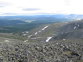
 Landscape in the northern part of the Ural Mountains (Khanty-Mansi Autonomous Okrug) | |
| Highest point | |
| Peak | Mount Narodnaya |
| Geography | |
| Countries | |
| Range coordinates | 60°N 59°E / 60°N 59°E |
| Geology | |
| Orogeny | Uralian orogeny |
| Rock age | Carboniferous |
| Rock type(s) | Metamorphic, igneous, sedimentary |
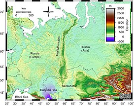
The Ural Mountains (/ˈjʊərəl/ YOOR-əl),[a] or simply the Urals, are a mountain range in Eurasia that runs north–south mostly through the Russian Federation, from the coast of the Arctic Ocean to the river Ural and northwestern Kazakhstan.[1] The mountain range forms part of the conventional boundary between the continents of Europe and Asia, marking the separation between European Russia and Siberia. Vaygach Island and the islands of Novaya Zemlya form a further continuation of the chain to the north into the Arctic Ocean. The average altitudes of the Urals are around 1,000–1,300 metres (3,300–4,300 ft), the highest point being Mount Narodnaya, which reaches a height of 1,894 metres (6,214 ft).[2]
The mountains lie within the Ural geographical region and significantly overlap with the Ural Federal District and the Ural economic region. Their resources include metal ores, coal, and precious and semi-precious stones. Since the 18th century, the mountains have contributed significantly to the mineral sector of the Russian economy. The region is one of the largest centres of metallurgy and heavy industry production in Russia.[3]
Cite error: There are <ref group=lower-alpha> tags or {{efn}} templates on this page, but the references will not show without a {{reflist|group=lower-alpha}} template or {{notelist}} template (see the help page).
- ^ Ural Mountains Archived 29 April 2015 at the Wayback Machine, Encyclopædia Britannica on-line
- ^ Cite error: The named reference
heightwas invoked but never defined (see the help page). - ^ Russian Regional Economic and Business Atlas. International Business Publications. August 2013. p. 42. ISBN 9781577510291.
