Back مقاطعة فان بورين (آيوا) Arabic Van Buren County, Iowa BAR Ван Бюрън (окръг, Айова) Bulgarian ভেন বুরেন কাউন্টি, আইৱা BPY Van Buren Gông (Iowa) CDO Ван-Бьюрен (гуо, Айова) CE Van Buren County (kondado sa Tinipong Bansa, Iowa) CEB Van Buren County, Iowa Welsh Van Buren County (Iowa) German Κομητεία Βαν Μπιούρεν (Άιοβα) Greek
Van Buren County | |
|---|---|
 | |
 Location within the U.S. state of Iowa | |
 Iowa's location within the U.S. | |
| Coordinates: 40°45′00″N 91°57′06″W / 40.75°N 91.951666666667°W | |
| Country | |
| State | |
| Founded | December 7, 1836 |
| Named for | Martin Van Buren |
| Seat | Keosauqua |
| Largest city | Keosauqua |
| Area | |
| • Total | 491 sq mi (1,270 km2) |
| • Land | 485 sq mi (1,260 km2) |
| • Water | 5.7 sq mi (15 km2) 1.2% |
| Population (2020) | |
| • Total | 7,203 |
| • Density | 15/sq mi (5.7/km2) |
| Time zone | UTC−6 (Central) |
| • Summer (DST) | UTC−5 (CDT) |
| Congressional district | 2nd |
| Website | www |
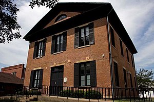
Van Buren County (/væn ˈbjʊərən/ van BURE-ən) is a county located in the U.S. state of Iowa. As of the 2020 census the population was 7,203, making it the state's tenth-least populous county.[1] The county seat is Keosauqua,[2] which contains the oldest continuously operational courthouse in the state of Iowa, and second oldest in the United States.
- ^ "2020 Census State Redistricting Data". census.gov. United states Census Bureau. Retrieved August 12, 2021.
- ^ "Find a County". National Association of Counties. Retrieved June 7, 2011.