Back فارل Arabic فارل (بلده فى فريسلاند) ARZ فارل AZB Varel Catalan Фарель CE Varel (munisipyo) CEB Varel Danish Varel German Varel Esperanto Varel Spanish
Varel | |
|---|---|
 Pedestrian area in Varel | |
 Flag  Coat of arms | |
Location of Varel within Friesland district 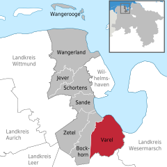 | |
 Varel  Varel | |
| Coordinates: 53°23′49″N 08°08′10″E / 53.39694°N 8.13611°E | |
| Country | Germany |
| State | Lower Saxony |
| District | Friesland |
| Subdivisions | 32 districts |
| Government | |
| • Mayor (2021–26) | Gerd-Christian Wagner[1] (SPD) |
| Area | |
| • Total | 113.53 km2 (43.83 sq mi) |
| Highest elevation | 12 m (39 ft) |
| Lowest elevation | 0 m (0 ft) |
| Population (2022-12-31)[2] | |
| • Total | 24,397 |
| • Density | 210/km2 (560/sq mi) |
| Time zone | UTC+01:00 (CET) |
| • Summer (DST) | UTC+02:00 (CEST) |
| Postal codes | 26316 |
| Dialling codes | 04451 |
| Vehicle registration | FRI |
| Website | www.varel.de |

Varel (German pronunciation: [ˈfaːʁəl] ) is a town in the district of Friesland, in Lower Saxony, Germany. It is situated near the Jade River and the Jade Bight, approximately 15 kilometres (9.3 mi) south of Wilhelmshaven and 30 kilometres (19 mi) north of Oldenburg. With a population of 23,984 (2020) it is the biggest town in the district of Friesland.