Back مقاطعة فيغو (إنديانا) Arabic ویقو بؤلگهسی، ایندیانا AZB Vigo County, Indiana BAR Виго (окръг, Индиана) Bulgarian ভিগ কাউন্টি, ইন্ডিয়ানা BPY Vigo Gông (Indiana) CDO Виго (гуо, Индиана) CE Vigo County CEB Vigo County, Indiana Welsh Vigo County German
Vigo County | |
|---|---|
 Vigo County Courthouse in Terre Haute | |
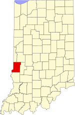
 Location within the U.S. state of Indiana | |
 Indiana's location within the U.S. | |
| Coordinates: 39°26′N 87°23′W / 39.43°N 87.39°W | |
| Country | |
| State | |
| Founded | February 1, 1818 |
| Named for | Francis Vigo |
| Seat | Terre Haute |
| Largest city | Terre Haute |
| Area | |
| • Total | 410.45 sq mi (1,063.1 km2) |
| • Land | 403.31 sq mi (1,044.6 km2) |
| • Water | 7.14 sq mi (18.5 km2) 1.74% |
| Population (2020) | |
| • Total | 106,153 |
| • Density | 263.0/sq mi (101.5/km2) |
| Time zone | UTC−5 (Eastern) |
| • Summer (DST) | UTC−4 (EDT) |
| Congressional district | 8th |
| Website | www |
| Indiana county number 84 | |
Vigo County (/ˈviːɡoʊ/ VEE-goh) is a county on the western border of the U.S. state of Indiana. According to the 2020 United States Census, it had a population of 106,153.[1] Its county seat is Terre Haute.[2]
Vigo County is included in the Terre Haute metropolitan area.
The county contains four incorporated settlements with a total population of nearly 63,000, as well as several unincorporated communities. It is divided into twelve townships which provide local services to the residents.[3]
The county was once regarded as one of the best bellwether regions for voting in U.S. presidential elections; it voted for the winning candidate in every election from 1956 to 2016[4] and in all but three elections since 1888.[5] Until the streak ended in 2020, only one county in the United States, Valencia County, New Mexico, had voted for the winning candidate longer.[6][7]
- ^ "Vigo County QuickFacts". US Census Bureau. Retrieved May 18, 2022.
- ^ "Find a County". National Association of Counties. Archived from the original on May 31, 2011. Retrieved June 7, 2011.
- ^ "Indiana Township Association". Retrieved September 12, 2010.
- ^ David Leip (2003). "Bellwether States and Counties". Retrieved May 17, 2008.
- ^ David Leip (2013). "Vigo County Extends Bellwether Streak". Retrieved October 26, 2015.
- ^ "Indiana Election……………Results". The New York Times. 2020. Retrieved November 8, 2020.
- ^ "Vigo County loses its bellwether status after 16 presidential elections". MyWabashValley.com. November 8, 2020. Retrieved November 9, 2020.