Back فيروفيتيشكا (مقاطعة) Arabic Komitat Virovititz German Ζουπανία Βιροβίτιτσκα Greek Virovitica (historia departemento) Esperanto Virovitica (ancien comitat) French Virovitička županija Croatian Verőce vármegye Hungarian Virovitica (comitaat) Dutch Komitat Verőce Polish Comitatul Virovitica Romanian
| Virovitica County | |||||||
|---|---|---|---|---|---|---|---|
| County of the Kingdom of Slavonia, Kingdom of Croatia-Slavonia and the Kingdom of Serbs, Croats and Slovenes | |||||||
| 12th–16th century 1718–1920/1922 | |||||||
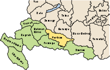
 Location of the County (yellow) within the Kingdom of Croatia-Slavonia (green) | |||||||
| Capital | Osijek | ||||||
| Area | |||||||
| • Coordinates | 45°33′N 18°41′E / 45.550°N 18.683°E | ||||||
• 1910 | 4,867 km2 (1,879 sq mi) | ||||||
| Population | |||||||
• 1910 | 272,430 | ||||||
| History | |||||||
• Established | 12th century | ||||||
• Treaty of Trianon | 4 June 1920 | ||||||
| 1922 | |||||||
| |||||||
| Today part of | Croatia | ||||||
| History of Slavonia |
|---|
 |

Virovitica County (Croatian: Virovitička županija; Hungarian: Verőce vármegye) was an administrative subdivision (županija) of the Medieval Kingdom of Croatia, the Kingdom of Slavonia and the Kingdom of Croatia-Slavonia. Slavonia was an autonomous kingdom within both Croatia and Hungary, themselves within the Habsburg Monarchy/Austrian Empire; Croatia-Slavonia, its successor, was an autonomous kingdom within the Lands of the Crown of Saint Stephen (Transleithania), the Hungarian part of Austria-Hungary. Its territory is now in eastern Croatia. The name of the county comes from the town of Virovitica (Hungarian: Verőce). The capital of the county moved from Virovitica to Osijek (Croatian; Hungarian: Eszék) in the late 18th century.
