Back مقاطعة فولوسيا (فلوريدا) Arabic ڤولوسيا كاونتى، فلوريدا ARZ وولوسیا بؤلگهسی، فلوریدا AZB Volusia County, Florida BAR Волуша (окръг, Флорида) Bulgarian ভোলুসিয়া কাউন্টি, ফ্লোরিডা BPY Volusia Gông (Florida) CDO Волуси (гуо, Флорида) CE Volusia County CEB Volusia County Czech
Volusia County | |
|---|---|
 Volusia County courthouse in DeLand, built in 2001 | |
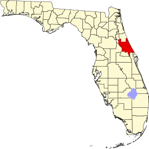
 Location within the U.S. state of Florida | |
 Florida's location within the U.S. | |
| Coordinates: 29°3′N 81°9′W / 29.050°N 81.150°W | |
| Country | |
| State | |
| Founded | December 29, 1854 |
| Named for | Community of Volusia |
| Seat | DeLand |
| Largest city | Deltona |
| Area | |
| • Total | 1,432.44 sq mi (3,710.0 km2) |
| • Land | 1,101.03 sq mi (2,851.7 km2) |
| • Water | 331.40 sq mi (858.3 km2) 23.14% |
| Population | |
| • Total | 553,543 |
| • Density | 503/sq mi (194/km2) |
| Time zone | UTC−5 (Eastern) |
| • Summer (DST) | UTC−4 (EDT) |
| Congressional districts | 6th, 7th |
| Website | www |
Volusia County (/vəˈluːʃə/, və-LOO-shə) is a county located in the east-central part of the U.S. state of Florida between the St. Johns River and the Atlantic Ocean. As of the 2020 census, the county was home to 553,543 people, an increase of 11.9% from the 2010 census.[1][2] It was founded on December 29, 1854, from part of Orange County, and was named for the community of Volusia, located in northwestern Volusia County. Its first county seat was Enterprise. Since 1887, its county seat has been DeLand.[3]
Volusia County is part of the Deltona–Daytona Beach–Ormond Beach metropolitan statistical area, as well as part of the larger Orlando–Deltona–Daytona Beach Combined statistical area.
- ^ a b "2020 Population and Housing State Data". United States Census Bureau. Retrieved September 10, 2021.
- ^ "U.S. Census Bureau QuickFacts: Volusia County, Florida". www.census.gov.
- ^ "Find a County". National Association of Counties. Archived from the original on May 31, 2011. Retrieved June 7, 2011.
