Back والا والا (واشنطن) Arabic والا والا, واشنطن ARZ والا والا، واشینقتون AZB Уола Уола Bulgarian Walla Walla (ciutat) Catalan Волла-Волла (Вашингтон) CE Walla Walla (kapital sa kondado) CEB Walla Walla, Washington Welsh Walla Walla Danish Walla Walla DAG
Walla Walla | |
|---|---|
 Reynolds–Day Building, Sterling Bank, and Baker Boyer Bank buildings in downtown Walla Walla | |
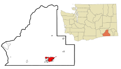
 Location of Walla Walla, Washington | |
| Coordinates: 46°3′54″N 118°19′49″W / 46.06500°N 118.33028°W | |
| Country | United States |
| State | Washington |
| County | Walla Walla |
| Government | |
| • Type | Council–manager |
| • Body | City council |
| • Mayor | Tom Scribner |
| • City manager | Elizabeth Chamberlain |
| Area | |
| • City | 13.88 sq mi (35.95 km2) |
| • Land | 13.85 sq mi (35.86 km2) |
| • Water | 0.03 sq mi (0.08 km2) |
| Elevation | 942 ft (287 m) |
| Population | |
| • City | 34,060 |
| • Estimate (2023)[3] | 33,339 |
| • Density | 2,376.14/sq mi (917.42/km2) |
| • Urban | 55,805 (US: 464th) |
| • Metro | 62,682 (US: 382th) |
| Time zone | UTC−8 (PST) |
| • Summer (DST) | UTC−7 (PDT) |
| ZIP Code | 99362 |
| Area code | 509 |
| FIPS code | 53-75775 |
| GNIS feature ID | 1512769[4] |
| Website | wallawallawa.gov |
Walla Walla (/ˌwɑːlə ˈwɑːlə/ WAH-lə WAH-lə)[5] is a city in and the county seat of Walla Walla County, Washington, United States.[6] It had a population of 34,060 at the 2020 census,[2] estimated to have decreased to 33,339 as of 2023.[3] The combined population of the city and its two suburbs, the town of College Place and unincorporated Walla Walla East, is about 45,000.[7]
Walla Walla is in the southeastern region of Washington, approximately four hours away from Portland, Oregon, and four and a half hours from Seattle. It is located only 6 mi (10 km) north of the Oregon border.
- ^ "2019 U.S. Gazetteer Files". United States Census Bureau. Retrieved August 7, 2020.
- ^ a b "Census Profile: Walla Walla, Washington". United States Census Bureau. Retrieved July 7, 2024.
- ^ a b Cite error: The named reference
USCensusEst2023was invoked but never defined (see the help page). - ^ "US Board on Geographic Names". United States Geological Survey. October 25, 2007. Retrieved January 31, 2008.
- ^ "Walla Walla". Merriam-Webster.com Dictionary. Merriam-Webster.
- ^ "Find a County". National Association of Counties. Retrieved June 7, 2011.
- ^ "Official Population Estimates". Washington State Office of Financial Management. Retrieved December 24, 2013.
