Back مقاطعة والا والا (واشنطن) Arabic Walla Walla County, Washington BAR Уола Уола (окръг) Bulgarian ৱালা ৱালা কাউন্টি, ৱাশিংটন BPY Comtat de Walla Walla Catalan Walla Walla Gông (Washington) CDO Уолла-Уолла (гуо, Вашингтон) CE Walla Walla County CEB Walla Walla County Czech Walla Walla County, Washington Welsh
Walla Walla County | |
|---|---|
 Walla Walla County Courthouse in 2024 | |
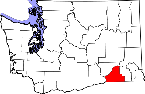
 Location within the U.S. state of Washington | |
 Washington's location within the U.S. | |
| Coordinates: 46°14′N 118°29′W / 46.23°N 118.48°W | |
| Country | |
| State | |
| Founded | April 25, 1854 |
| Named for | Walla Walla people |
| Seat | Walla Walla |
| Largest city | Walla Walla |
| Area | |
• Total | 1,299 sq mi (3,360 km2) |
| • Land | 1,270 sq mi (3,300 km2) |
| • Water | 29 sq mi (80 km2) 2.2% |
| Population (2020) | |
• Total | 62,584 |
• Estimate (2023) | 61,568 |
| • Density | 46/sq mi (17.8/km2) |
| Time zone | UTC−8 (Pacific) |
| • Summer (DST) | UTC−7 (PDT) |
| Congressional district | 5th |
| Website | co.walla-walla.wa.us |
Walla Walla County (/ˌwɑːlə ˈwɑːlə/ WAH-lə WAH-lə)[1] is a county located in the southeast of the U.S. state of Washington. As of the 2020 census, its population was 62,584.[2] The county seat and largest city is Walla Walla.[3] The county was formed on April 25, 1854[4] and is named after the Walla Walla tribe of Native Americans.
Walla Walla County is included in the Walla Walla, WA Metropolitan Statistical Area. As of 2020, the Walla Walla MSA is the second smallest metropolitan area in the United States, after the Carson City, Nevada MSA.
- ^ "Walla Walla". Merriam-Webster.com Dictionary. Merriam-Webster.
- ^ "State & County QuickFacts". United States Census Bureau. Retrieved November 10, 2024.
- ^ "Find a County". National Association of Counties. Retrieved June 7, 2011.
- ^ "Milestones for Washington State History — Part 2: 1851 to 1900". HistoryLink.org. March 6, 2003.
