Back مقاطعة والتون (فلوريدا) Arabic Walton County, Florida BAR Уолтън (окръг, Флорида) Bulgarian ৱালটন কাউন্টি, ফ্লোরিডা BPY Walton Gông (Florida) CDO Уолтон (гуо, Флорида) CE Walton County (kondado sa Tinipong Bansa, Florida) CEB Walton County, Florida Welsh Walton County (Florida) German Condado de Walton (Florida) Spanish
Walton County | |
|---|---|
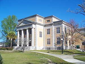
 Walton County Courthouse | |
 Location within the U.S. state of Florida | |
 Florida's location within the U.S. | |
| Coordinates: 30°37′N 86°10′W / 30.61°N 86.17°W | |
| Country | |
| State | |
| Founded | December 29, 1824 |
| Named for | George Walton Jr. |
| Seat | DeFuniak Springs |
| Largest community | Miramar Beach |
| Area | |
• Total | 1,240 sq mi (3,200 km2) |
| • Land | 1,038 sq mi (2,690 km2) |
| • Water | 202 sq mi (520 km2) 16.3% |
| Population (2020) | |
• Total | 75,305 |
• Estimate (2023) | 86,354 |
| • Density | 61/sq mi (23/km2) |
| Time zone | UTC−6 (Central) |
| • Summer (DST) | UTC−5 (CDT) |
| Congressional districts | 1st, 2nd |
| Website | www |
Walton County is a county located on the Emerald Coast in the northwestern part of the U.S. state of Florida, with its southern border on the Gulf of Mexico. As of the 2020 census, the population was 75,305.[1] Its county seat is DeFuniak Springs.[2] The county is home to the highest natural point in Florida: Britton Hill, at 345 feet (105 m). Walton County is included in the Crestview–Fort Walton Beach–Destin Metropolitan Statistical Area.
- ^ Cite error: The named reference
censuswas invoked but never defined (see the help page). - ^ "Find a County". National Association of Counties. Retrieved June 7, 2011.

