| Wappinger Creek | |
|---|---|
 Wappinger Creek at Red Oaks Mill at high flow | |
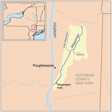
 Wappinger Creek Watershed | |
| Etymology | Native American Indians known as the "Wappinger" |
| Native name | Ma-we-na-wasigh (Munsee)[1] |
| Location | |
| Country | United States |
| State | New York |
| Region | Hudson Valley |
| County | Dutchess |
| Towns | Pine Plains, Stanford, Washington, Pleasant Valley, Poughkeepsie, LaGrange, Wappinger |
| Physical characteristics | |
| Source | Thompson Pond |
| • location | Pine Plains |
| • coordinates | 41°57′30″N 73°40′22″W / 41.95845°N 73.67284°W |
| • elevation | 450 ft (140 m) |
| Mouth | Hudson River |
• location | New Hamburg |
• coordinates | 41°34′56″N 73°56′52″W / 41.5823158°N 73.9479157°W |
• elevation | 0 ft (0 m) |
| Length | 41.7 mi (67.1 km), North–south |
| Basin size | 211 sq mi (550 km2) |
| [2] | |
Wappinger Creek is a 41.7-mile-long (67.1 km)[3] creek which runs from Thompson Pond to the Hudson River at New Hamburg in Dutchess County, New York, United States. It is the longest creek in Dutchess County, with the largest watershed in the county.
- ^ History of the Indian tribes of Hudson's River: their origin, manners and customs..., By Edward Manning Ruttenberg, page 370
- ^ "Wappinger Creek". Geographic Names Information System. United States Geological Survey, United States Department of the Interior. Retrieved 2012-12-04.
- ^ U.S. Geological Survey. National Hydrography Dataset high-resolution flowline data. The National Map Archived 2012-03-29 at the Wayback Machine, accessed October 3, 2011
