Wardija
Il-Wardija | |
|---|---|
Hamlet in St. Paul's Bay | |
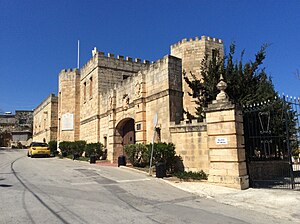
 View of the Castello Dei Baroni | |
 | |
| Coordinates: 35°56′16.65″N 14°23′33.15″E / 35.9379583°N 14.3925417°E | |
| Country | |
| Time zone | UTC+1 (CET) |
| • Summer (DST) | UTC+2 (CEST) |
| Postal code | SPB |
| ISO 3166 code | MT |
Wardija is a hamlet in St. Paul's Bay, Malta,[1] about 363 feet above sea level.[2] Its name is corrupted from the Sicilian or Italian word guardia, meaning 'to watch').[2][3] Although the name of the hamlet has Arabic lexicons, it was probably named later when Maltese, then an Arabic dialect, remained a dominant language.[4] The hamlet is bordered by Bidnija, Buġibba, San Martin and Pwales.[2] Several archeological remains found around the vicinity prove that it was inhabited in pre-history and the Roman period,[5] and it has always been mainly a rural village. From the 16th till the 18th centuries it saw a shift to a hunting zone with the construction of several hunting lodges and chapels.
A number of knights and noble families built their country residences, originally to be used for hunting and retreats. A number of 19th and 20th century structures were also erected in the area. Some houses are still owned by the descendants of the original builders, while others are now used for multiple purposes such as private homes, commercial accommodation, for holding events and weddings receptions. There are two schools, one for local students and one for foreign students.
There are a number of public and private chapels dating from the rule of the Order of St. John till the 20th century.[6] Some houses have buttressed walls, possibly for defense purposes or general support, while other have defense features exclusively for decorative intent. A World War I battery was constructed in the vicinity of Wardija, and its gun emplacements are still on site.[7] A rental complex, known as the Wardija Hilltop Village, and the Headquarters of the Ecumenical Order, known as Castello Dei Baroni, are located at the inner part of Wardija.[8]
Wardija consist of a low and high land, its hill is a plateau, and Qannotta Valley is located within its boundaries.[9] Rain water in Wardija is vital for agriculture, as a primary source of production, while it also flows into areas around such as to the now defunct Xemxija Aqueduct.[10] Some lands in Wardija enjoy a conservation status from the Environment and Resources Authority, while there are also pre-historic cart-ruts enjoying conservation from the Planning Authority.
- ^ "Call to protect small rural hamlets". Times of Malta. 3 October 2003.
- ^ a b c Aquilina, Guzè (1976). Maltese Linguistic Surveys. Malta University Press. p. 120.
- ^ "Studji Filologici" (PDF). Il-Malti (in Maltese): 50. 1957.
- ^ "page 377" (PDF). Melitensiawth.com. Retrieved 6 August 2018.
- ^ Sagona, Claudia (2015). The Archaeology of Malta. Cambridge University Press. p. 309. ISBN 9781107006690.
- ^ Scerri, John. "San Pawl". malta-canada.com. Retrieved 13 April 2017.
- ^ Debono, Charles (19 July 2015). "The western, eastern, Italian fronts in the latter half of 1915". Times of Malta. Archived from the original on 14 November 2015.
- ^ Dijkhof, Hans J. Hoegen; Dijkhof, Hendrik Johannes Hoegen (2006). The Legitimacy of Orders of St. John: A Historical and Legal Analysis and Case Study of a Para-religious Phenomenon. Hoegen Dijkhof Advocaten. pp. 24, 231, 457. ISBN 9789065509543.
- ^ "The Malta Government Gazette" (PDF). Gov.mt. 29 October 2013. Retrieved 6 August 2018.
- ^ "Het Wignacourt-aquaduct". Malta Pagina (in Dutch). Netherlands. 2005–2012. Archived from the original on 4 March 2016.
