Back وارموند ARZ Warmond CEB وارموند Persian Warmond French Warmond ID Warmond Italian Warmond Malay Warmond Dutch Warmond Polish Вармонд Russian
Warmond | |
|---|---|
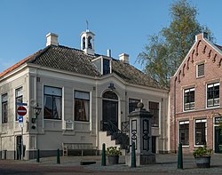
 Former Warmond Town Hall | |
| Coordinates: 52°11′50″N 4°30′6″E / 52.19722°N 4.50167°E | |
| Country | Netherlands |
| Province | South Holland |
| Municipality | Teylingen |
| Population (1 January 2021) | 5,020 |
Warmond (Dutch pronunciation: [ˈʋɑrmɔnt] ) is a village and former municipality in the Western Netherlands, north of Leiden in the province of South Holland. The municipality covered an area of 14.42 km2 (5.57 sq mi), of which 4.42 km2 (1.71 sq mi) is water; had a population of 4,977 in 2004. Together with Sassenheim and Voorhout, it became part of the Teylingen municipality on 1 January 2006. Warmond, which is located in an area called the "Dune and Bulb Region" (Duin- en Bollenstreek), is notable for being very affluent.
Warmond is situated on a lake system called Kagerplassen and has several marinas which make it a popular recreational area for boating and other water sports.
An 18th-century mansion called "Huys te Warmond" ("House at Warmond") is located north of the village along the main road.
The Major Seminary, Warmond, was founded here in 1799. Located in a converted in the former French Boarding School, it provided training for Priests until 1967.[1] The only known surviving copy of Joos Lambrecht Dutch-French dictionary, the Naembouck, was discovered by Wytze Hellinga in the library here shortly after it was closed.[2]
The first railway accident in the Netherlands occurred near Warmond on 10 March 1843. 1 person was killed.[3]
- ^ "Historie van het Groot Seminarie". www.teylingen.nl. Gemeente Teylingen. Retrieved 14 June 2021.
- ^ Cickx-Indestege, E. (1971). "The first edition of the Naembouck by Joos Lambrecht (1546)". Quaerendo. 1 (1): 13–15. doi:10.1163/157006971X00040.
- ^ Handleiding tot de kennis van de verschillende soorten van locomotieven, C.C. van Hall, 1844 (in Dutch)


