Back ونداور AZB Wendover (lungsod sa Hiniusang Gingharian, Inglatera, Buckinghamshire, lat 51,76, long -0,74) CEB Wendover Welsh Wendover (Buckinghamshire) Esperanto Wendover Spanish Wendover Basque ونداور Persian Wendover (Royaume-Uni) French Wendover Irish Wendover Italian
| Wendover | |
|---|---|
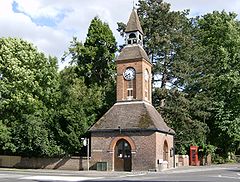
 The Clock Tower, Wendover | |
Location within Buckinghamshire | |
| Area | 9.1125 sq mi (23.601 km2) |
| Population | 7,399 (2011 Census)[1] |
| • Density | 812/sq mi (314/km2) |
| OS grid reference | SP864085 |
| Civil parish |
|
| Unitary authority | |
| Ceremonial county | |
| Region | |
| Country | England |
| Sovereign state | United Kingdom |
| Post town | AYLESBURY |
| Postcode district | HP22 |
| Dialling code | 01296 |
| Police | Thames Valley |
| Fire | Buckinghamshire |
| Ambulance | South Central |
| UK Parliament | |
| Website | Wendover Parish Council |
Wendover is a town [a] and civil parish at the foot of the Chiltern Hills in Buckinghamshire, England. It is situated at the point where the main road across the Chilterns between London and Aylesbury intersects with the once important road along the foot of the Chilterns. The town is 35 miles (56 km) north west of London and 5 miles (8 km) south east of Aylesbury.
The parish has an area of 5,832 acres (2,360 ha) and had, at the time of the 2011 census, a population of 7,399.[1] Outside Wendover, the parish is mainly arable and also contains several hamlets in the surrounding hills. Wendover has a weekly market, and has had a market charter since 1464.[3]
- ^ a b "Key Figures for 2011 Census: Key Statistics". Neighbourhood Statistics. Retrieved 2 February 2013.
- ^ "Wendover Conservation Area" (PDF). Aylesbury Vale District Council. December 2011. Archived (PDF) from the original on 24 August 2018. Retrieved 24 August 2018.
- ^ "Wendover Markets". Wendover Parish Council. Retrieved 2 August 2023.
Cite error: There are <ref group=lower-alpha> tags or {{efn}} templates on this page, but the references will not show without a {{reflist|group=lower-alpha}} template or {{notelist}} template (see the help page).
