| West Canada Creek | |
|---|---|
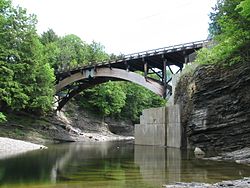
 View of West Canada Creek in Prospect Gorge | |
| Location | |
| Country | United States |
| State | New York |
| Counties | Hamilton, Oneida, Herkimer |
| Physical characteristics | |
| Source | West Lake, Mud Lake, South Lake |
| • location | Town of Arietta, Hamilton County |
| • coordinates | 43°35′14″N 74°36′49″W / 43.58722°N 74.61361°W[1] |
| Mouth | Mohawk River |
• location | Village of Herkimer, Herkimer County |
• coordinates | 43°01′16″N 74°57′46″W / 43.02111°N 74.96278°W[1] |
| Length | 76 mi (122 km) |
| Basin size | 565 sq mi (1,460 km2)[2] |
| Discharge | |
| • location | Kast Bridge, 4 miles (6.4 km) upstream from mouth[3] |
| • average | 1,356 cu ft/s (38.4 m3/s)[3] |
| • minimum | 20 cu ft/s (0.57 m3/s) (September 3, 1929)[3] |
| • maximum | 25,300 cu ft/s (720 m3/s) (June 28, 2013)[3] |
| Basin features | |
| Tributaries | |
| • left | South Branch West Canada Creek |
| • right | Honnedaga Brook, Cincinnati Creek |
| Waterfalls | Wilmurt Falls, Trenton Falls |
The West Canada Creek is a 76-mile-long (122 km)[4] river in upstate New York, United States. West Canada Creek is an important water way in Hamilton, Oneida, and Herkimer counties, draining the south part of the Adirondack Mountains before emptying into the Mohawk River near the Village of Herkimer. The name "Canada" is derived from an Iroquoian word for "village" (Kanata).
- ^ a b "West Canada Creek". Geographic Names Information System. United States Geological Survey, United States Department of the Interior. Retrieved August 15, 2016.
- ^ "USGS 0134609505 WEST CANADA CREEK AT MOUTH AT HERKIMER NY". National Water Information System. United States Geological Survey. 2019. Retrieved May 31, 2019.
- ^ a b c d "01346000 West Canada Creek at Kast Bridge, NY, Water Data Report 2013" (PDF). National Water Information System. United States Geological Survey. 1920–2013. Retrieved August 18, 2016.
- ^ U.S. Geological Survey. National Hydrography Dataset high-resolution flowline data. The National Map, accessed October 3, 2011


