Back ويست هام ARZ وستهام AZB West Ham Welsh West Ham Danish West Ham German West Ham (Londres) Spanish وستهام Persian West Ham (Londres) French West Ham Irish West Ham Hungarian
| West Ham | |
|---|---|
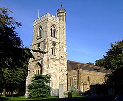
 All Saints’ Church, serving the Ancient Parish of West Ham | |
Location within Greater London | |
| Population | 15,551 (2011 Census, Ward)[1] |
| OS grid reference | TQ405837 |
| • Charing Cross | 6.1 mi (9.8 km) WSW |
| London borough | |
| Ceremonial county | Greater London |
| Region | |
| Country | England |
| Sovereign state | United Kingdom |
| Post town | LONDON |
| Postcode district | E15 |
| Dialling code | 020 |
| Police | Metropolitan |
| Fire | London |
| Ambulance | London |
| UK Parliament | |
| London Assembly | |
West Ham is a district in East London, England and is in the London Borough of Newham. It is an inner-city suburb located 6.1 mi (9.8 km) east of Charing Cross.
The area was originally an ancient parish formed to serve parts of the older Manor of Ham, and it later became a County Borough. The parish and borough of West Ham, situated east of the River Lea and north of the River Thames, was an administrative unit, with largely consistent boundaries, from the 12th century to 1965, when it merged with neighbouring areas to become the western part of the new London Borough. Before 1965 the area was part of the historic county of Essex.
West Ham's long established boundaries take in the sub-districts of Stratford, Canning Town, Plaistow, Custom House, Silvertown, Forest Gate and the western parts of Upton Park which is shared with East Ham.
The district was historically dependent on its docks and other maritime trades, while the inland industrial concentrations led to its byname as the Factory centre of the south of England.[2] These sources of employment have largely been lost, though there has been a degree of regeneration, in part associated with the 2012 Olympic Games.
- ^ UK Census (2011). "Local Area Report – West Ham 2011 Census Ward (1237320157)". Nomis. Office for National Statistics. Retrieved 18 March 2018.
- ^ Brewers Dictionary of London Phrase and Fable, Russ Willey, Chambers 2009
