Back Wes-Ghats Afrikaans الغات الغربية Arabic جاتس الغربيه ARZ পশ্চিমঘাট পৰ্বতমালা Assamese Ghats occidentales AST Qərbi Qat Azerbaijani Көнбайыш Гат тауҙары Bashkir Заходнія Гаты Byelorussian Западни Гхати Bulgarian पच्छिमी घाट Bihari
| Western Ghats | |
|---|---|
| Sahyadri | |
 Anamudi, the highest peak in the Western Ghats | |
| Highest point | |
| Peak | Anamudi, Eravikulam National Park |
| Elevation | 2,695 m (8,842 ft) |
| Coordinates | 10°10′11″N 77°03′40″E / 10.16972°N 77.06111°E |
| Dimensions | |
| Length | 1,600 km (990 mi) N–S |
| Width | 100 km (62 mi) E–W |
| Area | 160,000 km2 (62,000 sq mi) |
| Geography | |
| Country | India |
| Regions | Western and Southern India |
| States | |
| Biome | |
| Geology | |
| Rock age | Cenozoic |
| Rock types | |
| Criteria | Natural: ix, x |
| Reference | 1342 |
| Inscription | 2012 (36th Session) |
| Area | 795,315 ha |
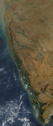
The Western Ghats, also known as the Sahyadri, is a mountain range that stretches 1,600 km (990 mi) along the western coast of the Indian peninsula. Covering an area of 160,000 km2 (62,000 sq mi), it traverses the states of Gujarat, Maharashtra, Goa, Karnataka, Kerala, and Tamil Nadu. The range forms an almost continuous chain of mountains along the western edge of the Deccan Plateau, from the Tapti River to Swamithoppe in Kanyakumari district at the southern tip of the Indian peninsula. The Western Ghats meet with the Eastern Ghats at Nilgiris before continuing south.
Geologic evidence indicates that the mountains were formed during the break-up of the supercontinent of Gondwana. The mountains came along the west coast of India somewhere in the late Jurassic and early Cretaceous periods when India separated from the African continent. The mountains can be roughly divided into three parts: the northern section with an elevation ranging from 900–1,500 m (3,000–4,900 ft), the middle section starting from the south of Goa with a lower elevation of less than 900 m (3,000 ft), and the southern section where the altitude rises again. The Western Ghats have several peaks that rise above 2,000 m (6,600 ft), with Anamudi (2,695 m (8,842 ft)) being the highest peak. The average elevation is around 1,200 m (3,900 ft).
The Western Ghats form one of the major watersheds of India, feeding many perennial river systems that drain almost 40% of the land area of the country. Because of the higher elevation of the Deccan plateau on the west, most rivers flow from eastwards towards the Bay of Bengal, resulting in chiselled eastern slopes and steeper western slopes facing the Arabian Sea. The Western Ghats play an important role in determining the climate and seasons in India. It blocks the rain-bearing monsoon winds flowing eastward from the Arabian Sea, resulting in rainfall along the western coast. By the time the air rises above the mountains, it becomes dry, forming a rain shadow region with very little rainfall on the leeward side towards the interior of the Deccan plateau.
The Western Ghats region is a biodiversity hotspot. It contains a large number of different species of flora and fauna, most of which are endemic to this region. At least 325 globally threatened species occur in the Western Ghats. The region was declared as a UNESCO World Heritage Site in 2012.
