Back Wit-Nyl Afrikaans ነጭ አባይ Amharic النيل الأبيض Arabic نهر النيل الابيض ARZ Ríu Nilu Blancu AST Ağ Nil Azerbaijani نیل سفید چایی AZB Аҡ Нил Bashkir Tukad Nil Putih BAN Белы Ніл Byelorussian
| White Nile Victoria Nile, Albert Nile, Mountain Nile | |
|---|---|
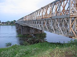
 A steel Bailey bridge spans the White Nile at Juba, South Sudan | |
 | |
| Location | |
| Country | Sudan, South Sudan, Rwanda, Tanzania, Uganda, Democratic Republic of the Congo, Ethiopia, Burundi |
| Cities | Jinja, Uganda, Juba, South Sudan, Khartoum, Sudan |
| Physical characteristics | |
| Source | White Nile |
| • location | Burundi[2] or Rwanda[3] |
| • coordinates | 2°16′56″S 29°19′52″E / 2.28222°S 29.33111°E |
| Length | 3,700 km (2,300 mi)[1] |
| Basin size | 1,800,000 km2 (690,000 sq mi) |
| Discharge | |
| • average | 878 m3/s (31,000 cu ft/s) |
| Basin features | |
| Tributaries | |
| • left | Albert Nile, Bahr el Ghazal |
| • right | Aswa, Sobat |
The White Nile (Arabic: النيل الأبيض an-nīl al-'abyaḍ) is a river in Africa, the minor of the two main tributaries of the Nile, the larger being the Blue Nile.[4] The name "White" comes from the clay sediment carried in the water that changes the water to a pale color.[5]
In the strict meaning, "White Nile" refers to the river formed at Lake No, at the confluence of the Bahr al Jabal and Bahr el Ghazal Rivers. In the wider sense, "White Nile" refers to all the stretches of river draining from Lake Victoria through to the merger with the Blue Nile: the "Victoria Nile" from Lake Victoria via Lake Kyoga to Lake Albert, then the "Albert Nile" to the South Sudan border, and then the "Mountain Nile" or "Bahr-al-Jabal" down to Lake No.[6] "White Nile" may sometimes include the headwaters of Lake Victoria, the most remote of which being 3,700 km (2,300 mi) from the Blue Nile.[1]
The 19th-century search by Europeans for the source of the Nile was mainly focused on the White Nile, which disappeared into the depths of what was then known as "Darkest Africa".

- ^ a b Penn, James R. (2001). Rivers of the World: A Social, Geographical, and Environmental Sourcebook. ABC-CLIO. p. 299. ISBN 9781576070420. Archived from the original on 30 March 2023. Retrieved 30 March 2023.
- ^ "Nile Africa | Africa Nile | Nile Valley | Mystery Nile | Nile White | Egypt Nile | Ancient Capital Nile". 10 January 2007. Archived from the original on 10 January 2007.
- ^ "Team reaches Nile's 'true source'". 31 March 2006. Archived from the original on 10 November 2013. Retrieved 22 April 2020 – via news.bbc.co.uk.
- ^ Elsanabary, Mohamed Helmy Mahmoud Moustafa (2012), Teleconnection, Modeling, Climate Anomalies Impact and Forecasting of Rainfall and Streamflow of the Upper Blue Nile River Basin, Canada: University of Alberta, doi:10.7939/R3377641M, hdl:10402/era.28151
- ^ The New American Cyclopaedia: A Popular Dictionary of General Knowledge, Volume 12. 1867. p. 362. Archived from the original on 30 March 2023. Retrieved 30 March 2023.
- ^ Dumont, Henri J. (2009). The Nile: Origin, Environments, Limnology and Human Use. Springer Science & Business Media. pp. 344–345. ISBN 9781402097263. Archived from the original on 30 March 2023. Retrieved 30 March 2023.