Back Witsee Afrikaans Cwēnsǣ ANG البحر الأبيض Arabic البحر الابيض ARZ Mar Blancu AST Ağ dəniz Azerbaijani آغ دنیز AZB Аҡ диңгеҙ Bashkir Segara Putih BAN Белае мора Byelorussian
You can help expand this article with text translated from the corresponding article in Russian. (August 2019) Click [show] for important translation instructions.
|
| White Sea | |
|---|---|
 | |
| Location | Eastern Europe |
| Coordinates | 65°30′N 37°30′E / 65.500°N 37.500°E |
| Type | Sea |
| Basin countries | Russia |
| Surface area | 90,000 km2 (34,700 sq mi) |
| Average depth | 60 m (197 ft) |
| Max. depth | 340 m (1,115 ft) |
| References | [1][2] |
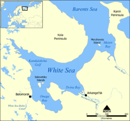
The White Sea (Russian: Белое море, romanized: Beloye more; Karelian and Finnish: Vienanmeri, lit. 'Dvina Sea'; Nenets: Сэрако ямʼ, romanized: Serako yam) is a southern inlet of the Barents Sea located on the northwest coast of Russia. It is surrounded by Karelia to the west, the Kola Peninsula to the north, and the Kanin Peninsula to the northeast. The whole of the White Sea is under Russian sovereignty and considered to be part of the internal waters of Russia.[3] Administratively, it is divided between the Arkhangelsk and Murmansk oblasts and the Republic of Karelia.
The major port of Arkhangelsk is located on the White Sea. For much of Russia's history this was Russia's main centre of international maritime trade, conducted by the Pomors ("seaside settlers") from Kholmogory. In the modern era it became an important Soviet naval and submarine base. The White Sea–Baltic Canal connects the White Sea with the Baltic Sea.
The White Sea is one of the four seas named (not only in English) after common colour terms—the others being the Black, Red and Yellow seas.
- ^ White Sea, Great Soviet Encyclopedia (in Russian)
- ^ White Sea, Encyclopædia Britannica on-line
- ^ A. D. Dobrovolskyi and B. S. Zalogin "Seas of USSR. White Sea", Moscow University (1982) (in Russian)
