Back وايتهفن ARZ وهیتهاون AZB Уайтхейвън Bulgarian Whitehaven CEB Whitehaven Welsh Whitehaven Danish Whitehaven German Whitehaven Spanish Whitehaven Basque وایتهیون Persian
| Whitehaven | |
|---|---|
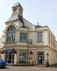
 Whitehaven Market Hall | |
Location within Cumbria | |
| Population | 23,986 (2011) |
| OS grid reference | NX974181 |
| Civil parish |
|
| Unitary authority | |
| Ceremonial county | |
| Region | |
| Country | England |
| Sovereign state | United Kingdom |
| Post town | WHITEHAVEN |
| Postcode district | CA28 |
| Dialling code | 01946 |
| Police | Cumbria |
| Fire | Cumbria |
| Ambulance | North West |
| UK Parliament | |
Whitehaven is a town and port on the English north west coast and near to the Lake District National Park in Cumberland, Cumbria, England. It lies by road 38 miles (61 km) south-west of Carlisle and 45 miles (72 km) to the north of Barrow-in-Furness. It was the administrative seat of the former Borough of Copeland, and has a town council for the parish of Whitehaven. The population of the town was 23,986 at the 2011 census.[2]
The town's growth was largely due to the exploitation of the extensive coal measures by the Lowther family, driving a growing export of coal through the harbour from the 17th century onwards. It was also a major port for trading with the American colonies, and was, after London, the second busiest port of England by tonnage from 1750 to 1772.[citation needed] This prosperity led to the creation of a Georgian planned town in the 18th century which has left an architectural legacy of over 170 listed buildings. Whitehaven has been designated a "gem town" by the Council for British Archaeology due to the historic quality of the town environment.[3]
Whitehaven was the site of a major chemical industry after World War II, but both that and the coal industry have disappeared, and today the major industry is the nearby Sellafield nuclear complex, which is the largest local employer of labour and has a significant administrative base in the town. Whitehaven includes a number of former villages, estates and suburbs, such as Mirehouse, Woodhouse, Kells and Hensingham, and is served by the Cumbrian coast railway line and the A595 road.
- ^ "Whitehaven Town Council Website". Whitehaven Town Council. Retrieved 7 November 2021.
- ^ "Town population 2011". Retrieved 25 January 2016.
- ^ ISGAP.org.uk Retrieved 1 March 2019. One of the 51 towns in UK "considered to be particularly splendid and precious"

