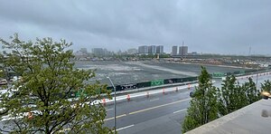
Willets Point | |
|---|---|
 Willets Point in 2024 | |
 Location within New York City | |
| Coordinates: 40°45′29″N 73°50′31″W / 40.758°N 73.842°W | |
| Country | |
| State | |
| City | |
| County/Borough | |
| Community District | Queens 7[1] |
| Population | |
| • Estimate (2011) | 10 |
| Time zone | UTC−5 (Eastern) |
| • Summer (DST) | UTC−4 (EDT) |
| ZIP Code | 11368 |
| Area codes | 718, 347, 929, and 917 |
Willets Point, also known locally as the Iron Triangle, is an industrial neighborhood within Corona, in the New York City borough of Queens. Located east of Citi Field near the Flushing River, it has been known for its automobile shops and junkyards. It had a population of 10 people in 2011.
Proposals to redevelop Willets Point started after World War II, but gained full traction in 2007. New York City Council members and the few residents of the area strongly opposed the original plan, leading to several years of lawsuits. In 2011, the city began a $4 billion redevelopment project to construct a retail shopping center, residential buildings with a combined 3,000 units, an entertainment complex, and a public school. The New York City Economic Development Corporation's plan to redevelop the area was approved in 2013, and demolition of the industrial section of Willets Point began in 2016.
The new development was originally set to open in stages between 2018 and 2032. However, the redevelopment plans were changed after a New York state court blocked the construction of the shopping center. The development was re-approved in February 2018.
- ^ "NYC Planning | Community Profiles". communityprofiles.planning.nyc.gov. New York City Department of City Planning. Retrieved April 7, 2018.
- ^ Cite error: The named reference
Bilefsky 2011was invoked but never defined (see the help page).
