Back Williamstown (lungsod sa Ostralya, State of South Australia) CEB Williamstown (South Australia) German ویلیامز تاون، استرالیای جنوبی Persian Williamstown (Australie-Méridionale) French Williamstown (Australia) Polish Williamstown, South Australia Swedish ولیمزٹاؤن، جنوبی آسٹریلیا Urdu
This article needs additional citations for verification. (May 2018) |
| Williamstown South Australia | |||||||||||||||
|---|---|---|---|---|---|---|---|---|---|---|---|---|---|---|---|
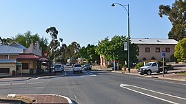
 Queen Street, the main street of Williamstown | |||||||||||||||
| Coordinates | 34°40′20″S 138°53′18″E / 34.67212°S 138.888362°E[1] | ||||||||||||||
| Population | 2,755 (2016 census)[2] | ||||||||||||||
| Established | 1857 (private sub-division) 15 March 2003 (locality)[3][4] | ||||||||||||||
| Postcode(s) | 5351 | ||||||||||||||
| Elevation | 310 m (1,017 ft) | ||||||||||||||
| Location | |||||||||||||||
| LGA(s) | Barossa Council | ||||||||||||||
| State electorate(s) | Schubert | ||||||||||||||
| Federal division(s) | Barker | ||||||||||||||
| |||||||||||||||
| |||||||||||||||
| Footnotes | Locations[1] Adjoining localities[1] | ||||||||||||||
Williamstown is a small South Australian town on the southern fringe of the Barossa Valley wine-growing region. It is 51 km north east of Adelaide and 16 km south-east of Gawler. Williamstown was originally known as Victoria Creek.[5] The township was laid out in 1858 by Lewis Johnston, or Johnstone, on land he purchased in 1857, and named for his son.[3]
Williamstown has an elevation of 310 m and an average rainfall of 680 mm. It has a summer average temperature of 31 °C with temperatures often reaching the mid 40s, and a winter average temperature of 15 °C, with nights dropping below freezing, which makes the region excellent for the cultivation of fruits, especially grapes in the lower riverine alluvial deposits.
- ^ a b c "Search results for 'Williamstown, LOCB' with the following datasets being selected – 'NPW and Conservation Properties', 'Suburbs and Localities', 'Counties', 'Local Government Areas', 'SA Government Regions', 'Gazetteer' and 'Roads'". Location SA Map Viewer. Government of South Australia. Retrieved 17 May 2018.
- ^ Australian Bureau of Statistics (27 June 2017). "Williamstown (SA) (State Suburb)". 2016 Census QuickStats. Retrieved 4 May 2018.
- ^ a b "Manning index of South Australian placenames". State Library of South Australia. Retrieved 1 April 2015.
- ^ Weatherill, Jay (15 May 2003). "GEOGRAPHICAL NAMES ACT 1991 Notice to Assign Names and Boundaries to Places (in the Barossa Council)" (PDF). The South Australian Government Gazette. South Australian Government. p. 1947. Retrieved 23 May 2018.
- ^ Rodney Cockburn, Stewart Cockburn South Australia – What's in a Name? Axiom Publishing 1990 ISBN 0 9592519 1 X
