Back Prefektur Yamaguchi ACE Yamaguchi-prefektuur Afrikaans ياماغوتشي (محافظة) Arabic محافظه ياماجوتشى ARZ Yamaquçi prefekturası Azerbaijani یاماقوچی اوستانی AZB Préféktur Yamaguchi BAN Ямагуты (прэфектура) Byelorussian Ямагучи (префектура) Bulgarian ইয়ামাগুচি প্রশাসনিক অঞ্চল Bengali/Bangla
Yamaguchi Prefecture
山口県 | |
|---|---|
| Japanese transcription(s) | |
| • Japanese | 山口県 |
| • Rōmaji | Yamaguchi-ken |
 View of Iwakuni City, Yamaguchi Prefecture from Iwakuni Castle. The famous Kintai Five Bow Bridge can be seen over the Nishiki River. | |
| Anthem: Yamaguchi kenmin no uta | |
 | |
| Country | Japan |
| Region | Chūgoku (Sanyo) |
| Island | Honshu |
| Capital | Yamaguchi |
| Largest city | Shimonoseki |
| Subdivisions | Districts: 4, Municipalities: 19 |
| Government | |
| • Governor | Tsugumasa Muraoka |
| Area | |
| • Total | 6,112.30 km2 (2,359.97 sq mi) |
| • Rank | 23rd |
| Population (February 1, 2018) | |
| • Total | 1,377,631 |
| • Rank | 25th |
| • Density | 225.43/km2 (583.9/sq mi) |
| GDP | |
| • Total | JP¥ 6,350 billion US$ 58.3 billion (2019) |
| ISO 3166 code | JP-35 |
| Website | www |
| Symbols of Japan | |
| Bird | Hooded crane (Grus monacha) |
| Fish | Japanese puffer (Takifugu rubripes) |
| Flower | Bitter summer mandarin blossom (Citrus natsudaidai) |
| Tree | Red pine tree (Pinus densiflora) |
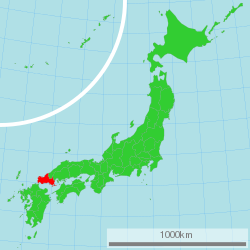
Yamaguchi Prefecture (山口県, Yamaguchi-ken) is a prefecture of Japan located in the Chūgoku region of Honshu.[2] Yamaguchi Prefecture has a population of 1,377,631 (1 February 2018) and has a geographic area of 6,112 km2 (2,359 sq mi). Yamaguchi Prefecture borders Shimane Prefecture to the north and Hiroshima Prefecture to the northeast.
Yamaguchi is the capital and Shimonoseki is the largest city of Yamaguchi Prefecture, with other major cities including Ube, Shūnan, and Iwakuni.[3] Yamaguchi Prefecture is located at the western tip of Honshu with coastlines on the Sea of Japan and Seto Inland Sea, and separated from the island of Kyushu by the Kanmon Straits.
- ^ "2020年度国民経済計算(2015年基準・2008SNA) : 経済社会総合研究所 - 内閣府". 内閣府ホームページ (in Japanese). Retrieved 2023-05-18.
- ^ Nussbaum, Louis-Frédéric. (2005). "Yamaguchi-ken" in Japan Encyclopedia, pp. 1039-1040, p. 1039, at Google Books; "Chūgoku" at p. 127, p. 127, at Google Books.
- ^ Nussbaum, "Yamaguchi" at p. 1039, p. 1039, at Google Books.

