| Yass Cohen Creek[1] | |
|---|---|
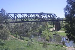
 A railway bridge over the Yass River. | |
Location of the Yass River mouth in New South Wales | |
| Etymology |
|
| Location | |
| Country | Australia |
| State | New South Wales |
| Region | South Eastern Highlands (IBRA), Riverina, Southern Tablelands, South Western Slopes |
| LGAs | Queanbeyan–Palerang, Yass Valley |
| City | Yass |
| Physical characteristics | |
| Source | Great Dividing Range |
| • location | near Wamboin |
| • elevation | 758 m (2,487 ft) |
| Mouth | confluence with the Murrumbidgee River |
• location | Lake Burrinjuck |
• coordinates | 34°52′36″S 148°46′55″E / 34.87667°S 148.78194°E |
• elevation | 345 m (1,132 ft) |
| Length | 139 km (86 mi) |
| Basin features | |
| River system | Murrumbidgee catchment, Murray-Darling basin |
| Tributaries | |
| • left | Back Creek (New South Wales), Murrumbateman Creek |
| • right | Cohen Creek, Black Joes Creek, Bungendore Creek, Brooks Creek, Derringullen Creek |
| [1][3] | |
The Yass River, a perennial river[1] that is part of the Murrumbidgee catchment within the Murray–Darling basin, is located in the Southern Tablelands and South Western Slopes districts of New South Wales, Australia.
- ^ a b c "Yass River". Geographical Names Register (GNR) of NSW. Geographical Names Board of New South Wales. Retrieved 20 January 2013.
- ^ "Yass". Geographical Names Register (GNR) of NSW. Geographical Names Board of New South Wales. Retrieved 20 January 2013.
- ^ "Map of Yass River". Bonzle Digital Atlas of Australia. Retrieved 20 January 2013.

