Back يانفو Arabic Yunfu Catalan Hùng-pù CDO Yunfu (kapital sa prepektura sa Pangmasang Republika sa Tśina) CEB Jün-fu Czech Yunfu Welsh Yunfu Danish Yunfu German Yunfu Spanish Yunfu Basque
Yunfu
云浮市 | |
|---|---|
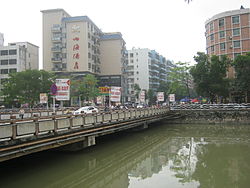
 Yunfu in 2013. Bridge over Nanshan river. | |
 | |
 Location of Yunfu in Guangdong | |
| Coordinates (Yunfu administrative service center (云浮市人民政府行政服务中心)): 22°54′55″N 112°02′40″E / 22.9152°N 112.0445°E | |
| Country | People's Republic of China |
| Province | Guangdong |
| County-level divisions | 5 |
| Township divisions | 112 |
| Incorporated as Linyun County | 111 CE |
| Yunfu County formed | May 1914 |
| Promoted to prefecture-level city | April 5, 1994 |
| City seat | Yuncheng District |
| Government | |
| Area | |
| 7,813.4 km2 (3,016.8 sq mi) | |
| Elevation | 133 m (436 ft) |
| Population (2020 census) | |
| 2,383,400 | |
| • Density | 310/km2 (790/sq mi) |
| • Urban | 369,321 |
| GDP[1] | |
| • Prefecture-level city | CN¥ 113.9 billion US$ 17.7 billion |
| • Per capita | CN¥ 47,685 US$ 7,391 |
| Time zone | China Standard |
| Area code | 766 |
| ISO 3166 code | CN-GD-53 |
| License Plate | 粤W |
| Major Nationalities | Han |
| Website | Official website |
| Yunfu | |||||||||||||||||||||
|---|---|---|---|---|---|---|---|---|---|---|---|---|---|---|---|---|---|---|---|---|---|
 "Yunfu", as written in Chinese calligraphy | |||||||||||||||||||||
| Simplified Chinese | 云浮 | ||||||||||||||||||||
| Traditional Chinese | 雲浮 | ||||||||||||||||||||
| Hanyu Pinyin | Yúnfú | ||||||||||||||||||||
| Cantonese Yale | Wàhnfàuh | ||||||||||||||||||||
| Postal | Wanfow | ||||||||||||||||||||
| Literal meaning | Cloud Drift | ||||||||||||||||||||
| |||||||||||||||||||||
Yunfu (simplified Chinese: 云浮; traditional Chinese: 雲浮; pinyin: Yúnfú), formerly romanized as Wanfow, and historically known as Dong'an (simplified Chinese: 东安; traditional Chinese: 東安; pinyin: Dōng'ān), which was formerly romanized as Tong On, from 1578 to 1913, is a prefecture-level city in western Guangdong province, People's Republic of China. It borders Zhaoqing to the north, Foshan to the east, Jiangmen to the southeast, Yangjiang to the south, Maoming to the southwest, and the autonomous region of Guangxi to the west. The city spans an area of 7,786.64 square kilometres (3,006.44 sq mi), and has a population of 2,383,400 according to a 2021 publication by the city government.[2]
- ^ 广东省统计局、国家统计局广东调查总队 (August 2016). 《广东统计年鉴-2016》. 中国统计出版社. ISBN 978-7-5037-7837-7. Archived from the original on 2017-12-22.
- ^ 云浮概况 [Yunfu Overview]. yunfu.gov.cn (in Chinese). Yunfu Municipal People's Government. 2021-06-04. Archived from the original on 2021-07-17. Retrieved 2021-07-17.
