Back Zaltbommel Afrikaans زالتبومل Arabic زالتبومل ARZ Zaltbommel Catalan Gemeente Zaltbommel CEB Zaltbommel German Zaltbommel Esperanto Zaltbommel Spanish Zaltbommel Basque زالتبومل Persian
Zaltbommel
Bommel | |
|---|---|
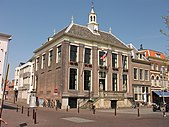
Saint Martin church City hall Gasthuis Tower Market Maarten van Rossum museum Water gate | |
| Coordinates: 51°48′N 5°15′E / 51.800°N 5.250°E | |
| Country | Netherlands |
| Province | Gelderland |
| Government | |
| • Body | Municipal council |
| • Mayor | Peter Rehwinkel (acting) (PvdA) |
| Area | |
| • Total | 89.04 km2 (34.38 sq mi) |
| • Land | 79.38 km2 (30.65 sq mi) |
| • Water | 9.66 km2 (3.73 sq mi) |
| Elevation | 3 m (10 ft) |
| Population (January 2021)[4] | |
| • Total | 29,447 |
| • Density | 371/km2 (960/sq mi) |
| Time zone | UTC+1 (CET) |
| • Summer (DST) | UTC+2 (CEST) |
| Postcode | 5300–5311, 5315–5318 |
| Area code | 0418 |
| Website | www |
Zaltbommel (Dutch pronunciation: [zɑldˈbɔməl] ), also known, historically and colloquially, as Bommel, is a municipality and a city in the Netherlands.
- ^ "Burgemeester Van den Bosch" [Mayor Van den Bosch] (in Dutch). Gemeente Zaltbommel. Retrieved 24 July 2014.
- ^ "Kerncijfers wijken en buurten 2020" [Key figures for neighbourhoods 2020]. StatLine (in Dutch). CBS. 24 July 2020. Retrieved 19 September 2020.
- ^ "Postcodetool for 5301LB". Actueel Hoogtebestand Nederland (in Dutch). Het Waterschapshuis. Retrieved 24 July 2014.
- ^ "Bevolkingsontwikkeling; regio per maand" [Population growth; regions per month]. CBS Statline (in Dutch). CBS. 1 January 2021. Retrieved 2 January 2022.


