Back Cheografía de Cheorchia AN جغرافيا جورجيا Arabic Xeografía de Xeorxa AST Gürcüstan coğrafiyası Azerbaijani Геаграфія Грузіі Byelorussian География на Грузия Bulgarian জর্জিয়ার (রাষ্ট্র) ভূগোল Bengali/Bangla Geografia de Geòrgia Catalan Geography of Georgia (country) English Geografía de Georgia Spanish
| Geografi Georgia | |
|---|---|
 | |
| Benua | Eropa dan Asia |
| Kawasan | Kaukasus |
| Koordinat | 42°00′N 43°30′E / 42.000°N 43.500°E |
| Wilayah | Peringkat 119 69.700 km² (26.911,3 mil²) 100 % daratan 0% perairan |
| Perbatasan | 1.814 km (1.127 mi)
|
| Titik tertinggi | Gunung Shkhara 5.201 m (17.064 ft) |
| Titik terendah | Antara Poti dan Kulevi, (-1.5-2.3 m)[1] |
| Sungai terpanjang | Sungai Alazani 407 km (253 mi) |
| Danau terbesar | Danau Paravani, 375 km2 (145 sq mi) |
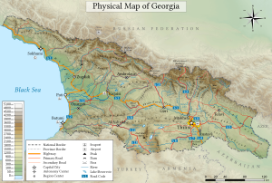
Georgia adalah sebuah negara di wilayah Kaukasus di pesisir Laut Hitam. Kadang-kadang dianggap sebagai negara lintas benua, terletak di persimpangan Eropa Timur dan Asia Barat,[2] dan saat ini secara umum dianggap sebagai bagian dari Eropa.[3][4][5][6] Georgia berbatasan dengan Rusia di utara dan timur laut, Turki dan Armenia di selatan, dan Azerbaijan di tenggara.[7]
- ^ Geography of Georgia - 9th grade book; G. Chanturia, D. Kereselidze; p. 43
- ^ "Caucasus - region and mountains, Eurasia". Encyclopedia Britannica. Diakses tanggal 26 November 2018. Quote: “One widely accepted scheme draws the dividing line along the crest of the Greater Caucasus range, putting the portion of the region north of the line in Europe...another scheme identifies the Aras River and the Turkish border as the line of continental demarcation, thereby locating...Georgia in Europe.”
- ^ International Geographic Encyclopaedia and Atlas. Springer: p. 273
- ^ Encyclopedic World Atlas, George Philip & Son, Oxford University Press: 2002, p.104
- ^ "Georgia - 46 States, one Europe". Council of Europe. Diakses tanggal 2023-08-12.
- ^ "Europe - Georgia". World Health Organization. Diakses tanggal 2023-08-12.
- ^ Nana Bolashvili, Andreas Dittmann, Lorenz King, Vazha Neidze (eds.): National Atlas of Georgia, 138 pages, Steiner Verlag, 2018, ISBN 978-3-515-12057-9