Back Prefektur Akita ACE Akita-prefektuur Afrikaans أكيتا (محافظة) Arabic Akita prefekturası Azerbaijani آکیتا اوستانی AZB Préféktur Akita BAN Акіта (прэфектура) Byelorussian Акита (префектура) Bulgarian আকিতা প্রশাসনিক অঞ্চল Bengali/Bangla Prefectura d'Akita Catalan
| Prefectuur in Japan | |||
|---|---|---|---|

| |||
| Situering | |||
| Eiland | Honshu | ||
| Regio | Tohoku | ||
| Coördinaten | 39°43'7"NB, 140°6'9"OL | ||
| Algemeen | |||
| Hoofdstad | Akita | ||
| Oppervlakte | 11.637,52 km² | ||
| % water | 0,7% | ||
| Inwoners | 985.021 (1 april 2018) | ||
| Dichtheid | 84,6 inw./km² | ||
| ISO 3166-2 | JP-05 | ||
| Prefectuurcode | 05000-8 | ||
| Bestuurlijke informatie | |||
| Gouverneur | Norihisa Satake | ||
| Adres | 4-1-1 Sanno, Akita-shi | ||
| Postcode | 〒010-8570 | ||
| Telefoonnummer | 018-860-1111 | ||
| Website | Akita-ken | ||
| Districten | 6 | ||
| Gemeenten | 65 | ||
| Symbolen | |||
| Bloem | Japans hoefblad | ||
| Boom | Japanse ceder | ||
| Vogel | Koperfazant (Syrmaticus soemmerringi) | ||
| Website | www | ||
| Detailkaart | |||

| |||
| ■:seirei shi / ■:shi / ■:chō・mura | |||
| |||
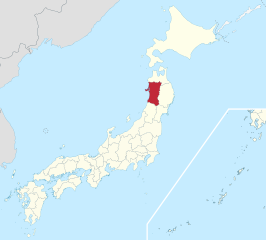
De prefectuur Akita (Japans: 秋田県, Akita-ken) is een Japanse prefectuur in het gewest Tohoku in het noorden van het eiland Honshu. De hoofdstad is de gelijknamige stad Akita.

