Back Durham (graafskap) Afrikaans Durham AN Dūnholmscīr ANG درم (مقاطعة) Arabic Condáu de Durham AST County Durham BAN Дарэм (графства) Byelorussian Дарэм (графства) BE-X-OLD Дърам (графство) Bulgarian Kontelezh Durham Breton
| County Durham | |||
| grevskap | |||
| Land | |||
|---|---|---|---|
| Region | Nordaust-England | ||
| Areal | 2 676 km² | ||
| Folketal | 508 500 (2008) | ||
| Grunnlagd | Historisk | ||
| Status | Seremonielt grevskap og einskapleg styresmakt | ||
 County Durham 54°40′00″N 1°50′00″W / 54.666666666667°N 1.8333333333333°W | |||
| Wikimedia Commons: County Durham | |||
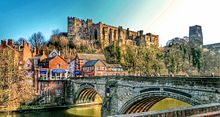
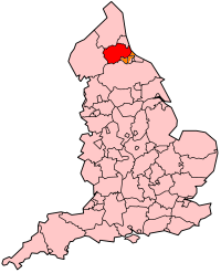
County Durham er eit seremonielt grevskap[1] og ei (mindre) einskapleg styresmakt nordaust i England. Administrasjonsbyen er Durham. Den største byen i det seremonielle grevskapet er Darlington.[2] Grevskapet har ein industribasert økonomi som historisk sett har vore basert på kol- og jerngruveindustrien.[3]
Det seremonielle grevskapet grensar til Tyne and Wear, North Yorkshire, Cumbria og Northumberland og ligg i regionen Nordaust-England.[4]
- ↑ Boundary Commission for England (2007). Mapping for the Non-metropoltian Counties og Unitary Authorities; fifth periodical report. Boundary Commission for England. ISBN 0101703228.
- ↑ John Marius Wilson, Durham, Imperial Gazetteer of England and Wales, (1870-72).
- ↑ Durham County Council - History og Heritage of County Durham.
- ↑ North East Assembly - About North East England Arkivert 2007-12-20 ved Wayback Machine..

