Back Мавританиа Abkhazian Mauritania ACE Мауритание ADY Mauritanië Afrikaans Mauretanien ALS ሞሪታኒያ Amharic Mauritania AMI Mauritania AN Mauritania ANG Mọritania ANN
Coordinates: 20°N 12°W / 20°N 12°W
Islamic Republic o Mauritanie | |
|---|---|
Motto: شرف إخاء عدل (Arabic) "Honor, Fraternity, Juistice" | |
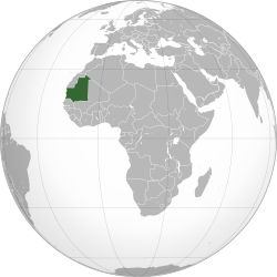
 Location of Mauritania (green) in Africae | |
 | |
| Caipital and largest city | Nouakchott 18°09′N 15°58′W / 18.150°N 15.967°W |
| Offeecial leids | Arabica |
| Recognised naitional leids | |
| Ither leids | French[1] Zenaga Berber |
| Releegion | Islam |
| Demonym(s) | Mauritanian |
| Govrenment | Unitar semi-presidential Islamic republic |
• Preses | Mohamed Ould Ghazouanib |
| Mohamed Ould Bilalb | |
| Legislatur | Pairlament |
| Naitional Assemmly | |
| Independence | |
• from Fraunce | 28 November 1960 |
• Current Constitution o Mauritanie | 12 Julie 1991 |
| Aurie | |
• Total | 1,030,000 km2 (400,000 sq mi)[2] (28t) |
• Water (%) | 0.03 |
| Population | |
• 2016 estimate | 4,301,018[3] |
• 2013 census | 3,537,368[2] |
• Density | 3.4/km2 (8.8/sq mi) |
| GDP (PPP) | 2017 estimate |
• Total | $17.421 billion[4] (134th) |
• Per capita | $4,488[4] (140t) |
| GDP (nominal) | 2017 estimate |
• Tot | $5.063 billion[4] (154t) |
• Per capita | $1,304[4] (149t) |
| Gini (2008) | 40.5[5] medium |
| HDI (2015) | law · 157t |
| Currency | Ouguiya (MRO) |
| Time zone | UTC+0 (GMT) |
| Drivin side | richt |
| Cawin code | +222 |
| ISO 3166 code | MR |
| Internet TLD | .mr |
Warning: Page uisin Template:Infobox kintra wi unkent parameter "country_code" (this message is shown only in preview).
Warning: Page uisin Template:Infobox kintra wi unkent parameter "area_magnitude" (this message is shown only in preview).

Mauritanie (Arabic: موريتانيا Mūrītāniyā; Wolof: Gànnaar; Soninke: Murutaane; Pulaar: Moritani; French: Mauritanie), offeecially the Islamic Republic o Mauritanie, is a kintra in North Africae. It is bordered bi the Atlantic Ocean in the wast, bi Wastren Sahara in the north, bi Algerie in the northeast, bi Mali in the east an sootheast, an bi Senegal in the soothwast. It is named efter the Roman province o Mauretanie, even tho the modren state covers a territory far tae the soothwest o the auld province. The caipital an lairgest ceety is Nouakchott, locatit on the Atlantic coast.
- ↑ "États généraux de l'Éducation nationale en Mauritanie". Le Quotidien de Nouakchott. 13 November 2011. Archived frae the original on 14 Apryle 2013. Unknown parameter
|deadurl=ignored (help) - ↑ a b "1: Répartition spatiale de la population" (PDF). Recensement Général de la Population et de l’Habitat (RGPH) 2013 (Report) (in French). National Statistical Office of Mauritania. Julie 2015. p. v. Retrieved 20 December 2015.[deid airtin]
- ↑ "World Population Prospects: The 2017 Revision". ESA.UN.org (custom data acquired via website). United Nations Department of Economic and Social Affairs, Population Division. Retrieved 10 September 2017.
- ↑ a b c d "Mauritania". International Monetary Fund.
- ↑ "Gini Index". World Bank. Retrieved 2 Mairch 2011.
- ↑ "2016 Human Development Report" (PDF). United Nations Development Programme. 2016. Retrieved 21 Mairch 2017.

